IMAGES TAKEN NEAR TO
WOTTON-UNDER-EDGE, GL12 7JN
Introduction
This page details the photographs taken nearby to GL12 7JN by members of the Geograph project.
The Geograph project started in 2005 with the aim of publishing, organising and preserving representative images for every square kilometre of Great Britain, Ireland and the Isle of Man.

There are currently over 7.5m images from over14,400 individuals and you can help contribute to the project by visiting https://www.geograph.org.uk
Image Map
Images are licensed for reuse under creativecommons.org/licenses/by-sa/2.0
Notes
- Clicking on the map will re-center to the selected point.
- The higher the marker number, the further away the image location is from the centre of the postcode.
Image Listing (296 Images Found)
Images are licensed for reuse under creativecommons.org/licenses/by-sa/2.0
Image
Details
Distance
1
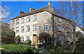
Waterloo Mill - Wotton-under-Edge
Textile mill built as a steam mill in 1815. Now converted to dwellings. There is an 1815 datestone on this elevation.
Image: © Chris Allen
Taken: 10 Mar 2019
0.01 miles
2
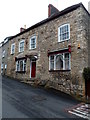
Former Shearmans Arms in Wotton-under-Edge
Built in the early 19th century, number 5 School Road,
at the bottom of Ludgate Hill, was for decades the Shearmans Arms Inn.
Image: © Jaggery
Taken: 28 Oct 2012
0.02 miles
3
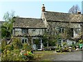
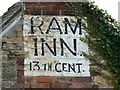
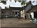
Ram Inn, Potters Pond, Wotton under Edge
This is a view of the rear extension of the ancient inn facing west. The building is in a generally poor state but what potential! Deep pockets would be needed to restore the place though. The property has been used in the last forty years as a bed and breakfast but no longer. It remains the home of the current owner who lives in a state of benign neglect.
Next image http://www.geograph.org.uk/photo/775527
Image: © Brian Robert Marshall
Taken: 22 Apr 2008
0.03 miles
4

Flower garden, Ram Inn, Potters Pond, Wotton under Edge
The owner of the inn created this display by the imaginative use of old milk crates and the like. It works well. The cross, he told me, marks the position of a ley line that runs from Stonehenge to this location. I wouldn't rule out the possibility.
First image in series http://www.geograph.org.uk/photo/775508
Image: © Brian Robert Marshall
Taken: 22 Apr 2008
0.03 miles
5
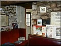
Ram Inn interior, Potter's Pond, Wotton under Edge
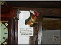
One of two images intended to provide an indication of the character of the interior of this old building. There are several newspaper cuttings to be seen, mostly focusing on the various ghosts that reportedly inhabit the place. The owner was, it has been stated, yanked out of bed on his first night in residence by one of the incumbents wishing to make his or her presence known. Second interior http://www.geograph.org.uk/photo/779810
Image: © Brian Robert Marshall
Taken: 22 Apr 2008
0.03 miles
6
Ram Inn interior, Potter's Pond, Wotton under Edge
The second of two images intended to provide an indication of the character of the interior of this old building. This is in the roof-space where, one is told, highwaymen would hide up from the forces of law and order. Back to main tour http://www.geograph.org.uk/photo/775516
Image: © Brian Robert Marshall
Taken: 22 Apr 2008
0.03 miles
7
Ram Inn pub sign, Potters Pond, Wotton under Edge
The sign has been painted high up on the western gable end of this fascinating old inn.
Next image http://www.geograph.org.uk/photo/775526
Image: © Brian Robert Marshall
Taken: 22 Apr 2008
0.03 miles
8
Ram Inn
The sadly neglected Ram Inn at Wotton under Edge.
Image: © don cload
Taken: 6 May 2017
0.03 miles
9
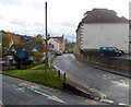
Junction of School Road and Potters Pond, Wotton-under-Edge
School Road is on the right.
Image: © Jaggery
Taken: 28 Oct 2012
0.03 miles
10
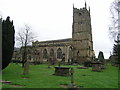
Wotton-under-Edge (Glos) St Mary the Virgin's Church
Image: © ChurchCrawler
Taken: 4 Dec 2004
0.03 miles