IMAGES TAKEN NEAR TO
Waterley Bottom, DURSLEY, GL11 6AE
Introduction
This page details the photographs taken nearby to Waterley Bottom, GL11 6AE by members of the Geograph project.
The Geograph project started in 2005 with the aim of publishing, organising and preserving representative images for every square kilometre of Great Britain, Ireland and the Isle of Man.

There are currently over 7.5m images from over14,400 individuals and you can help contribute to the project by visiting https://www.geograph.org.uk
Image Map (Loading...)


Getting Data...Please wait
Leaflet Map data © OpenStreetMap
Images are licensed for reuse under creativecommons.org/licenses/by-sa/2.0
Notes
- Clicking on the map will re-center to the selected point.
- The higher the marker number, the further away the image location is from the centre of the postcode.
Image Listing (4 Images Found)
Images are licensed for reuse under creativecommons.org/licenses/by-sa/2.0
Image
Details
Distance
1
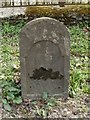
Old Milestone by the A4135, Coopers Wood, Dursley parish
Stone post (plate lost) by the A4135, in parish of DURSLEY (STROUD District), Coopers Wood; opposite footpath sign between house and garage on verge, by the road, on South side of road. TDW iron plate, erected by the Coldharbour District turnpike trust in the 19th century.
Inscription once read:-
(TETBURY 8)
(DURSLEY &)
(WOTTON 2)
Milestone Society National ID: GL_TBDY08.
Image: © M Faherty
Taken: 10 Apr 2010
0.17 miles
2
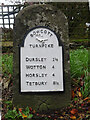
Old Milestone A4135, Coopers Wood
Stone post by the A4135, in parish of DURSLEY (STROUD District), Coopers Wood; opposite footpath sign between house and garage on verge, by the road, on South side of road. MS erected by the Coldharbour District turnpike trust in the 19th century. The modern plate was commissioned by the house owners (behind) and installed in 2020 with advice from the Milestone Society. Cancelled BM below plate was 639.5 ft ASL.
Earlier image see Image
Inscription: Dursley 1½ / Wotton 4 / Horsley 4 / Tetbury 8½
Milestone Society National ID: GL_TBDY08
Image: © Mr Red
Taken: 28 Oct 2021
0.18 miles
3
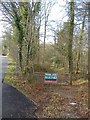
Folly Wood
'For Sale' on the ridge, north of the A4135.
Image: © Roger Cornfoot
Taken: 25 Jan 2007
0.18 miles
4
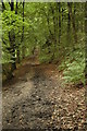
Folly Wood
Footpath through Folly Wood in the Uley valley.
Image: © Philip Halling
Taken: 5 Sep 2009
0.25 miles