IMAGES TAKEN NEAR TO
Weavers Drive, DURSLEY, GL11 5TL
Introduction
This page details the photographs taken nearby to Weavers Drive, GL11 5TL by members of the Geograph project.
The Geograph project started in 2005 with the aim of publishing, organising and preserving representative images for every square kilometre of Great Britain, Ireland and the Isle of Man.

There are currently over 7.5m images from over14,400 individuals and you can help contribute to the project by visiting https://www.geograph.org.uk
Image Map (Loading...)


Getting Data...Please wait
Leaflet Map data © OpenStreetMap
Images are licensed for reuse under creativecommons.org/licenses/by-sa/2.0
Notes
- Clicking on the map will re-center to the selected point.
- The higher the marker number, the further away the image location is from the centre of the postcode.
Image Listing (50 Images Found)
Images are licensed for reuse under creativecommons.org/licenses/by-sa/2.0
Image
Details
Distance
1
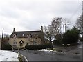
Uley Brewery
http://www.uleybrewery.com/history_brewery.htm . The brewery dates from 1833 but closed at the end of the nineteenth century. It reopened in 1985 thanks to Chas Wright.
Image: © Derek Harper
Taken: 5 May 2007
0.04 miles
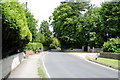
2
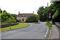
Road junction in Uley
The main road curves to the left, with two roads leading up the hill, Lampern View and New Cut
Image: © David Smith
Taken: 29 Dec 2017
0.06 miles
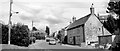
3
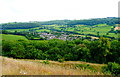
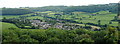
Uley Village from Uley Bury, Gloucestershire 2014
Image: © Ray Bird
Taken: 7 Aug 2014
0.07 miles

6
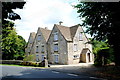
The Gables, Main Street, Uley, Gloucestershire 2014
Image: © Ray Bird
Taken: 7 Aug 2014
0.09 miles
8
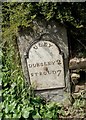
Old Milestone by the B4006, The Street, Uley
Metal plate attached to stone post by the B4066, in parish of ULEY (STROUD District), The Street, Uley, at West end of low wall on bend by Montpellier House, on North West side of road. Dursley plate, erected by the Berkley & Dursley (Division) turnpike trust in the 19th century.
Inscription reads:-
ULEY
DURSLEY 2
STROUD 7
Grade II listed.
List Entry Number: 1305553 https://historicengland.org.uk/listing/the-list/list-entry/1305553
Milestone Society National ID: GL_DYST02.
Image: © M Faherty
Taken: 10 Apr 2010
0.10 miles
10
Uley Village from Uley Bury, Gloucestershire 2014
Image: © Ray Bird
Taken: 7 Aug 2014
0.13 miles