1
Southern boundary of Cam
The A4135 Kingshill Road, Dursley behind the camera becomes the A4135 Tilsdown, Cam ahead.
Image: © Jaggery
Taken: 21 Jul 2012
0.07 miles
2
A4135 at the edge of Cam
Photo taken at the junction with the B4066
Image: © Ruth Sharville
Taken: 28 Jul 2012
0.08 miles
3
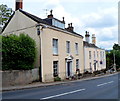
Georgian houses, Sandpits, Cam
These Dursley Road houses date from the 18th century.
Image: © Jaggery
Taken: 21 Jul 2012
0.09 miles
4
View over Tilsdown
Housing off Dursley Road, Cam
Image: © Jonathan Billinger
Taken: 7 Dec 2012
0.10 miles
5
Old Boundary Marker by the A4135, Kingshill Road, Cam parish
Parish Boundary Marker by the A4135, in parish of Cam (Stroud District), junction of Tilsdown with Dursley Road, by police station.
No inscription visible.
Carved bench mark and rivet on top.
Grade II listed.
List Entry Number: 1090920 https://historicengland.org.uk/listing/the-list/list-entry/1090920
To be surveyed
Milestone Society National ID: GL_CAMDUR01pb
Image: © Milestone Society
Taken: Unknown
0.11 miles
6
Lambsdowne, Cam
Viewed from the Dursley Road end. Lambsdowne is a cul-de-sac containing about 70 houses.
Image: © Jaggery
Taken: 21 Jul 2012
0.11 miles
7
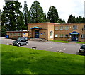
Police Station and Old Magistrates' Court, Dursley
The building is set back from the east side of Kingshill Road in the Sandpits area. The police station on the right is part of the Gloucestershire Constabulary. The former magistrates' court on the left is now a Gloucestershire County Council office, in use by the Community and Adult Care Directorate.
Image: © Jaggery
Taken: 21 Jul 2012
0.12 miles
8
Field access by Dursley Road, Tilsdown
Image: © David Smith
Taken: 29 Dec 2017
0.13 miles
9
Rare motor on Dursley Road
The Bristol 411(?) is not far from the factory of origin here on the B4066 at Cam.
Image: © Jonathan Billinger
Taken: 7 Dec 2012
0.14 miles
10
Destinations sign, Kingshill Road, Dursley
The sign is alongside the A4135 Kingshill Road at the northern edge of Dursley, near the Cam border.
Image: © Jaggery
Taken: 21 Jul 2012
0.16 miles


