Old Boundary Marker by the A4135, Kingshill Road, Cam parish
Introduction
The photograph on this page of Old Boundary Marker by the A4135, Kingshill Road, Cam parish by Milestone Society as part of the Geograph project.
The Geograph project started in 2005 with the aim of publishing, organising and preserving representative images for every square kilometre of Great Britain, Ireland and the Isle of Man.

There are currently over 7.5m images from over 14,400 individuals and you can help contribute to the project by visiting https://www.geograph.org.uk
Old Boundary Marker by the A4135, Kingshill Road, Cam parish
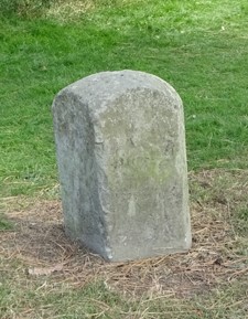
Image: © Milestone Society Taken: Unknown
Parish Boundary Marker by the A4135, in parish of Cam (Stroud District), junction of Tilsdown with Dursley Road, by police station. No inscription visible. Carved bench mark and rivet on top. Grade II listed. List Entry Number: 1090920 https://historicengland.org.uk/listing/the-list/list-entry/1090920 To be surveyed Milestone Society National ID: GL_CAMDUR01pb
Images are licensed for reuse under creativecommons.org/licenses/by-sa/2.0
Image Location
Latitude
51.691724
Longitude
-2.364404