IMAGES TAKEN NEAR TO
Kingshill, DURSLEY, GL11 5QE
Introduction
This page details the photographs taken nearby to Kingshill, GL11 5QE by members of the Geograph project.
The Geograph project started in 2005 with the aim of publishing, organising and preserving representative images for every square kilometre of Great Britain, Ireland and the Isle of Man.

There are currently over 7.5m images from over14,400 individuals and you can help contribute to the project by visiting https://www.geograph.org.uk
Image Map
Images are licensed for reuse under creativecommons.org/licenses/by-sa/2.0
Notes
- Clicking on the map will re-center to the selected point.
- The higher the marker number, the further away the image location is from the centre of the postcode.
Image Listing (24 Images Found)
Images are licensed for reuse under creativecommons.org/licenses/by-sa/2.0
Image
Details
Distance
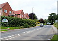
1
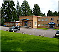
Police Station and Old Magistrates' Court, Dursley
The building is set back from the east side of Kingshill Road in the Sandpits area. The police station on the right is part of the Gloucestershire Constabulary. The former magistrates' court on the left is now a Gloucestershire County Council office, in use by the Community and Adult Care Directorate.
Image: © Jaggery
Taken: 21 Jul 2012
0.05 miles
2
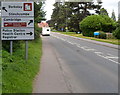
Destinations sign, Kingshill Road, Dursley
The sign is alongside the A4135 Kingshill Road at the northern edge of Dursley, near the Cam border.
Image: © Jaggery
Taken: 21 Jul 2012
0.05 miles
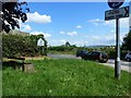
3
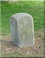
Old Boundary Marker by the A4135, Kingshill Road, Cam parish
Parish Boundary Marker by the A4135, in parish of Cam (Stroud District), junction of Tilsdown with Dursley Road, by police station.
No inscription visible.
Carved bench mark and rivet on top.
Grade II listed.
List Entry Number: 1090920 https://historicengland.org.uk/listing/the-list/list-entry/1090920
To be surveyed
Milestone Society National ID: GL_CAMDUR01pb
Image: © Milestone Society
Taken: Unknown
0.07 miles
4
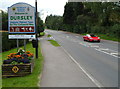
Northern boundary of Dursley
The A4135 Kingshill Road from Cam reaches Dursley, a small market town in Gloucestershire.
Image: © Jaggery
Taken: 21 Jul 2012
0.07 miles
5
Southern boundary of Cam
The A4135 Kingshill Road, Dursley behind the camera becomes the A4135 Tilsdown, Cam ahead.
Image: © Jaggery
Taken: 21 Jul 2012
0.10 miles
6
A4135 at the edge of Cam
Photo taken at the junction with the B4066
Image: © Ruth Sharville
Taken: 28 Jul 2012
0.10 miles
7
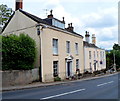
Georgian houses, Sandpits, Cam
These Dursley Road houses date from the 18th century.
Image: © Jaggery
Taken: 21 Jul 2012
0.11 miles
8
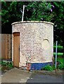
Oak at Kingshill (3) - outbuilding, 2 Kingshill Road, Dursley, Glos
This outbuilding is to be found in the car park of the Oak at Kingshill public house and restaurant. At a guess, and that is all it can be, it might just be an icehouse. Before refrigerators were invented, icehouses were built to store ice and insulating materials. Often the main purpose was to store foods or to keep drinks cool.
Image
Image
Image: © P L Chadwick
Taken: 12 Jul 2021
0.16 miles
9
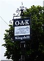
Oak at Kingshill (2) - sign, 2 Kingshill Road, Dursley, Glos
The sign shows a black and white drawing of the building. It is set on a post near the main road.
Image
Image
Image: © P L Chadwick
Taken: 12 Jul 2021
0.17 miles
10
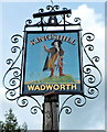
The Kingshill name sign, Dursley
The sign, and a flourish of metalwork, is on a post in a strip of grass alongside this http://www.geograph.org.uk/photo/3317975 pub.
Image: © Jaggery
Taken: 21 Jul 2012
0.17 miles