IMAGES TAKEN NEAR TO
Rosebery Mount, DURSLEY, GL11 4PR
Introduction
This page details the photographs taken nearby to Rosebery Mount, GL11 4PR by members of the Geograph project.
The Geograph project started in 2005 with the aim of publishing, organising and preserving representative images for every square kilometre of Great Britain, Ireland and the Isle of Man.

There are currently over 7.5m images from over14,400 individuals and you can help contribute to the project by visiting https://www.geograph.org.uk
Image Map
Images are licensed for reuse under creativecommons.org/licenses/by-sa/2.0
Notes
- Clicking on the map will re-center to the selected point.
- The higher the marker number, the further away the image location is from the centre of the postcode.
Image Listing (28 Images Found)
Images are licensed for reuse under creativecommons.org/licenses/by-sa/2.0
Image
Details
Distance
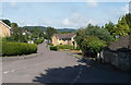
1
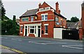
The Carpenters Arms, Dursley
Pub on Uley Road on the edge of Dursley. (There's no apostrophe on the sign so I haven't introduced one here.) Opposite it is a small hardware shop.
Image: © David Gruar
Taken: 20 Jan 2007
0.03 miles
2
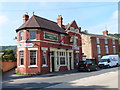
Carpenters Arms, Dursley
Pub at 32 Uley Road, near the corner of Rosebery Road.
Image: © Jaggery
Taken: 21 Jul 2012
0.03 miles
3
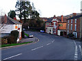
Highfields Approach, Dursley
The large street name sign shows that Highfields Approach leads to First Avenue,
Second Avenue, Third Avenue, Fourth Avenue, School Road and Rosebery Park.
This way also leads to Dursley Primary School. The shortest route is via Third Avenue.
Image: © Jaggery
Taken: 21 Jul 2012
0.03 miles
4
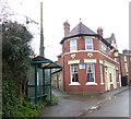
Bus shelter by the Carpenters Arms inn, Dursley
Image: © David Smith
Taken: 29 Dec 2017
0.04 miles
5
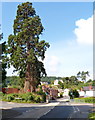
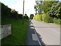
Very tall conifers, Uley Road, Dursley
There are two conifers here. The second one is mostly hidden by the one in front.
I don't know their height, but they dwarf the adjacent traffic lights and house.
Image: © Jaggery
Taken: 21 Jul 2012
0.05 miles
6
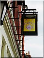
Carpenters Arms (2) - sign, 32 Uley Road, Dursley, Glos
The rather faded sign of the Carpenters Arms.
Image
Image: © P L Chadwick
Taken: 25 Jul 2021
0.05 miles
7
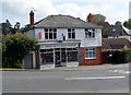
Dursley Farm & Garden Machinery shop
Shop at 21 Uley Road, near the Rosebery Road junction.
Image: © Jaggery
Taken: 21 Jul 2012
0.05 miles
8
Carpenters Arms (1), 32 Uley Road, Dursley, Glos
Traditional public house which, according to the WhatPub website, currently offers real cider but no cask ales.
Image
Image: © P L Chadwick
Taken: 25 Jul 2021
0.05 miles
9
Yellow Hundred Close, Dursley
Looking westwards from alongside a grade II listed former lodge. http://www.geograph.org.uk/photo/3053351
The unusual name Yellow Hundred is possibly the old name of this area. Historically, in England (and later Ireland), a hundred was a subdivision of a county having its own court. It is also unusual for a street name in the UK to start with "Yellow". According to one source, there are only about twenty such, all with unique names. The most common names are those starting with Yellowhammer, such as Yellowhammer Road (Basingstoke) and Yellowhammer Close (London NW9).
Image: © Jaggery
Taken: 21 Jul 2012
0.06 miles
10
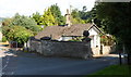
Grade II listed number 1 Ferney, Dursley
Located on the corner of Yellow Hundred Close and Ferney, on the north side of Uley Road.
Built in 1760 as the lodge for Ferney Hill, a Grade II listed former country house.
Number 1 Ferney was Grade II listed in December 1986.
Image: © Jaggery
Taken: 21 Jul 2012
0.06 miles