IMAGES TAKEN NEAR TO
Lawrence Grove, DURSLEY, GL11 4EZ
Introduction
This page details the photographs taken nearby to Lawrence Grove, GL11 4EZ by members of the Geograph project.
The Geograph project started in 2005 with the aim of publishing, organising and preserving representative images for every square kilometre of Great Britain, Ireland and the Isle of Man.

There are currently over 7.5m images from over14,400 individuals and you can help contribute to the project by visiting https://www.geograph.org.uk
Image Map
Images are licensed for reuse under creativecommons.org/licenses/by-sa/2.0
Notes
- Clicking on the map will re-center to the selected point.
- The higher the marker number, the further away the image location is from the centre of the postcode.
Image Listing (25 Images Found)
Images are licensed for reuse under creativecommons.org/licenses/by-sa/2.0
Image
Details
Distance
1
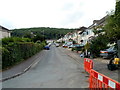
Lawrence Grove, Dursley
A view SSW from the edge of St Dominic's RC church. http://www.geograph.org.uk/photo/3317860
Image: © Jaggery
Taken: 21 Jul 2012
0.03 miles
2
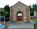
Front view of St Dominic's RC church, Dursley
Located on the corner of Lawrence Grove and Jubilee Road. The Roman Catholic church opened in February 1939. It was dedicated to St Dominic in recognition of the work of the Dominican friars in the area.
Image: © Jaggery
Taken: 21 Jul 2012
0.09 miles
3
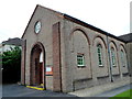
Side view of St Dominic's RC church, Dursley
The Roman Catholic church is on the corner of Lawrence Grove and Jubilee Road. It opened in February 1939, dedicated to St Dominic in recognition of the work of the Dominican friars in the area.
Image: © Jaggery
Taken: 21 Jul 2012
0.09 miles
4
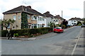
Jubilee Road, Dursley
This is the southern part of Jubilee Road, viewed from the corner of Kings Drive, looking towards Olive Grove.
Image: © Jaggery
Taken: 21 Jul 2012
0.10 miles
5
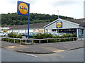
Lidl, Dursley
The Lidl site occupies all of the NW side of Kings Drive. Viewed from the corner of Kingshill Road looking towards Jubilee Road.
Image: © Jaggery
Taken: 21 Jul 2012
0.10 miles
6
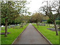
Path through Dursley Town Cemetery
The cemetery is in the north of Dursley, occupying a rectangular site about 220 metres long and 45 metres wide.
Image: © Jaggery
Taken: 21 Jul 2012
0.10 miles
7
St Dominic's presbytery, Dursley
The presbytery (priests' house) was built in 1954 on the north side of the church http://www.geograph.org.uk/photo/3317860
Image: © Jaggery
Taken: 21 Jul 2012
0.11 miles
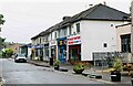
8
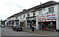
Kingshill Road shops, Dursley
The three shops nearest the camera are all food takeaways.
Image: © Jaggery
Taken: 21 Jul 2012
0.13 miles
9
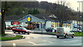
Lidl supermarket, Kingshill, Dursley
In the shadow of Sheep's Path Wood on the northern flank of Stinchcombe Hill.
Image: © Jonathan Billinger
Taken: 7 Dec 2012
0.13 miles
10
Parade of shops, Kingshill Parade, Kingshill Road, Dursley, Glos
A parade of shops located next to the Oak at Kingshill public house/restaurant. The parade includes takeaways.
Image: © P L Chadwick
Taken: 12 Jul 2021
0.13 miles