1
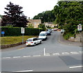
Garden Suburb, Dursley
Viewed across Kingshill Road. The street name sign shows Garden Suburb leading to Burnt Oak.
Image: © Jaggery
Taken: 21 Jul 2012
0.03 miles
2
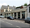
Restored Pike House and a modern extension, Dursley
The building in front is The Pike House, built in the early 19th century to collect tolls on the turnpike road linking Dursley with the Gloucester to Bristol turnpike road. Here's a view http://www.geograph.org.uk/photo/1810986 from 2010.
Image: © Jaggery
Taken: 21 Jul 2012
0.05 miles
3
Dursley, tollhouse
The Pike House, Kingshill Road; now appears to be abandoned. Listed by English Heritage, http://www.imagesofengland.org.uk/Details/Default.aspx?id=393833&mode=adv
Image: © Mike Faherty
Taken: 10 Apr 2010
0.05 miles
4
Old Toll House by Kingshill Road, Dursley
Toll House in the parish of Dursley (Stroud District), The Pike House, Kingshill Road (A4135), GL11.
Grade II listed.
List Entry Number: 1219991 https://historicengland.org.uk/listing/the-list/list-entry/1219991
Surveyed
Milestone Society National ID: GL.DUR
Image: © Alan Rosevear
Taken: Unknown
0.05 miles
5
Gulf filling station, Dursley
Formerly a Pace supplier
Image
Image: © David Smith
Taken: 29 Dec 2017
0.05 miles
6
Wild Goose Garage, Dursley
Pace petrol station and shop at 27 Kingshill Road.
Image: © Jaggery
Taken: 21 Jul 2012
0.05 miles
7
A glimpse inside Dursley Garage service and repairs area
Part of a large site in Kingshill Road.
Image: © Jaggery
Taken: 21 Jul 2012
0.06 miles
8
Dursley Garage, Dursley
This is the car showroom part of large premises on Kingshill Road.
Image: © Jaggery
Taken: 21 Jul 2012
0.07 miles
9
Kingshill Road elevated pavement, Dursley
Black railings line the edge of a section of pavement slightly elevated above the western side of the A4135 Kingshill Road.
Image: © Jaggery
Taken: 21 Jul 2012
0.09 miles
10
Cedar Drive, Dursley
Viewed across the A4135 which is named Parsonage Street to the south (left) of this junction and Kingshill Road to the north.
Image: © Jaggery
Taken: 21 Jul 2012
0.10 miles


