IMAGES TAKEN NEAR TO
Rednock Drive, DURSLEY, GL11 4BY
Introduction
This page details the photographs taken nearby to Rednock Drive, GL11 4BY by members of the Geograph project.
The Geograph project started in 2005 with the aim of publishing, organising and preserving representative images for every square kilometre of Great Britain, Ireland and the Isle of Man.

There are currently over 7.5m images from over14,400 individuals and you can help contribute to the project by visiting https://www.geograph.org.uk
Image Map
Images are licensed for reuse under creativecommons.org/licenses/by-sa/2.0
Notes
- Clicking on the map will re-center to the selected point.
- The higher the marker number, the further away the image location is from the centre of the postcode.
Image Listing (30 Images Found)
Images are licensed for reuse under creativecommons.org/licenses/by-sa/2.0
Image
Details
Distance
1
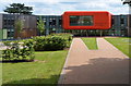
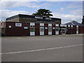
Rednock School, Dursley
This is the middle section of the recently-built specialist science school, viewed from Kingshill Road.
Image: © Jaggery
Taken: 21 Jul 2012
0.01 miles
2
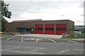
Dursley fire station
Dursley fire station, Kingshill Road, Dursley, Gloucestershire, which replaces the old station in Castle Street Image
Image: © Kevin Hale
Taken: 26 Jul 2009
0.10 miles
3
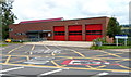
Dursley Fire Station
Dursley Community Fire and Rescue Station is located on the corner of Kingshill Road and Kingshill Lane. The station, part of Gloucestershire Fire and Rescue Service, opened in 2009, a replacement for the previous one http://www.geograph.org.uk/photo/176868 which was demolished to make way for a Sainsbury's store. http://www.geograph.org.uk/photo/3316457
Image: © Jaggery
Taken: 21 Jul 2012
0.13 miles
4
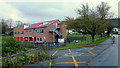
Dursley Fire Station
Viewed from Kingshill Lane.
Image: © Jonathan Billinger
Taken: 7 Dec 2012
0.14 miles
5
Rednock School
The front entrance to Rednock School, Dursley, Gloucestershire.
Image: © Colin Travis
Taken: 14 Jun 2005
0.15 miles
6
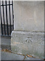
Benchmark, Sion Place, Bath
A cutmark (as listed in the Benchmark Database: http://www.bench-marks.org.uk/bm39458 ) on the column facing onto Bathwick Hill. See Image] for a wider view.
Image: © Neil Owen
Taken: 2 Sep 2011
0.15 miles
7
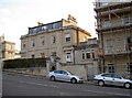
Georgian housing along Bathwick Hill
A wider view of this steep road leading down into Bath; a benchmark (one of several along the way) can be seen here: Image
Image: © Neil Owen
Taken: 2 Sep 2011
0.15 miles
8
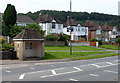
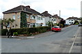
Bus shelter and houses, Kingshill Road, Dursley
The houses face Dursley Fire Station. http://www.geograph.org.uk/photo/3316471
Image: © Jaggery
Taken: 21 Jul 2012
0.16 miles
9
Jubilee Road, Dursley
This is the southern part of Jubilee Road, viewed from the corner of Kings Drive, looking towards Olive Grove.
Image: © Jaggery
Taken: 21 Jul 2012
0.16 miles
10
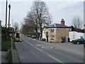
Dursley, tollhouse
The Pike House, Kingshill Road; now appears to be abandoned. Listed by English Heritage, http://www.imagesofengland.org.uk/Details/Default.aspx?id=393833&mode=adv
Image: © Mike Faherty
Taken: 10 Apr 2010
0.18 miles