IMAGES TAKEN NEAR TO
Tinkley Lane, STONEHOUSE, GL10 3UH
Introduction
This page details the photographs taken nearby to Tinkley Lane, GL10 3UH by members of the Geograph project.
The Geograph project started in 2005 with the aim of publishing, organising and preserving representative images for every square kilometre of Great Britain, Ireland and the Isle of Man.

There are currently over 7.5m images from over14,400 individuals and you can help contribute to the project by visiting https://www.geograph.org.uk
Image Map
Images are licensed for reuse under creativecommons.org/licenses/by-sa/2.0
Notes
- Clicking on the map will re-center to the selected point.
- The higher the marker number, the further away the image location is from the centre of the postcode.
Image Listing (11 Images Found)
Images are licensed for reuse under creativecommons.org/licenses/by-sa/2.0
Image
Details
Distance
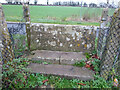
1
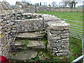
Stone Stile, Nympsfield
Step and slab stile has been re-built in the 20th C. This is looking West within the field along the line of Tinkley Lane, towards Nympsfield. The view from the road is Image
Image: © Mr Red
Taken: 15 Dec 2021
0.05 miles
2
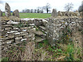
Stone Stile Nympsfield
Step and slab stile has been re-built in the 20th C. This is looking from Tinkley Lane. The view in the field looking West is Image
Image: © Mr Red
Taken: 15 Dec 2021
0.05 miles
3
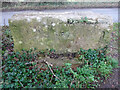
Stone Stile, Nympsfield
This has been covered in concrete to stabilise the stile. There is enough stone at the base of the LS edge to suggest the original slab is in there, if in pieces. The view is looking North to Tinkley Lane. The view South is Image The presence of a Benchmark (other side, representing 231.4 m ASL) would put the concreting before 1960. See photos: http://benchmarks.mister.red/#so80350082
Image: © Mr Red
Taken: 15 Dec 2021
0.08 miles
4
Stone Stile, Nympsfield
This has been covered in concrete to stabilise the stile. There is enough stone at the base of the RH edge to suggest the original slab is in there, if in pieces. The view is looking South from Tinkley Lane. The view North is Image The presence of a Benchmark (lower left, representing 231.4 m ASL) would put the concreting before 1960. See photos: http://benchmarks.mister.red/#so80350082
Image: © Mr Red
Taken: 15 Dec 2021
0.08 miles
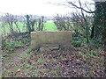
5
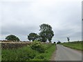
A new stone wall by Tinkley Lane, Nympsfield
Image: © David Smith
Taken: 8 Jun 2018
0.10 miles
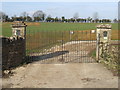
7
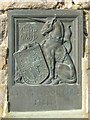
Plaque on entrance to King George's Field
On the right hand side of Image
Image: © John M
Taken: 18 Feb 2013
0.17 miles
8
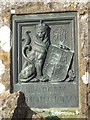
Plaque on entrance to King George's Field
On the left hand side of Image
Image: © John M
Taken: 18 Feb 2013
0.17 miles
9
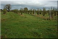
An orchard, Nympsfield
An orchard beside the road from Nympsfield to Nailsworth.
Image: © Philip Halling
Taken: 6 Nov 2010
0.18 miles
10
Stone Stile, Nympsfield
Looking out across the field to Tinkley Lane and another stone stile. The RC Primary School playing field is behind the camera. The view looking back (SW) is Image
Image: © Mr Red
Taken: 15 Dec 2021
0.23 miles