IMAGES TAKEN NEAR TO
Peter Street/Frog Lane, Peter Street, STONEHOUSE, GL10 3TQ
Introduction
This page details the photographs taken nearby to Peter Street/Frog Lane, Peter Street, GL10 3TQ by members of the Geograph project.
The Geograph project started in 2005 with the aim of publishing, organising and preserving representative images for every square kilometre of Great Britain, Ireland and the Isle of Man.

There are currently over 7.5m images from over14,400 individuals and you can help contribute to the project by visiting https://www.geograph.org.uk
Image Map
Images are licensed for reuse under creativecommons.org/licenses/by-sa/2.0
Notes
- Clicking on the map will re-center to the selected point.
- The higher the marker number, the further away the image location is from the centre of the postcode.
Image Listing (64 Images Found)
Images are licensed for reuse under creativecommons.org/licenses/by-sa/2.0
Image
Details
Distance
1
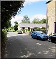
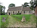
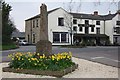
West along Peter's Street, Frocester
This is the road towards the remains of St Peter's church. http://www.geograph.org.uk/photo/2673699 The Frocester George inn is on the right.
Image: © Jaggery
Taken: 7 Aug 2016
0.08 miles
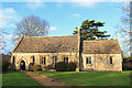
2
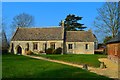
St Andrew, Frocester
Restored by Sidney Gambier Parry, who saved it from demolition, in 1896-7, it was originally built in 1680-90.
Image: © Philip Pankhurst
Taken: 18 Mar 2015
0.09 miles
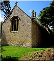
3
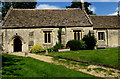
Path to St Andrew's Church, Frocester
The church is part of the Church of England Diocese of Gloucester. Formerly a chapel of ease dating from the 17th century, St Andrew's fell into a state of ruin after the Church of St Peter became the main village church in 1849. St Andrew's was extensively rebuilt in 1896-1897. After St Peter's Church was declared redundant in the early 1950s, St Andrew's became the Parish Church. St Andrew's was Grade II listed in 1955.
https://www.geograph.org.uk/photo/5677110 to the east side of St Andrew's.
Image: © Jaggery
Taken: 7 Aug 2016
0.09 miles
4
St Andrew, Frocester
A late 17th century chapel, restored by Sidney Gambier Parry in 1896-7.
Image: © Philip Pankhurst
Taken: 18 Mar 2015
0.09 miles
6
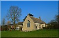
St Andrew's Church
Church in Frocester.
Image: © Wayland Smith
Taken: 5 Dec 2020
0.10 miles
7
East side of St Andrew's Church, Frocester
The church is part of the Church of England Diocese of Gloucester. Formerly a chapel of ease dating from the 17th century, St Andrew's fell into a state of ruin after the Church of St Peter became the main village church in 1849. St Andrew's was extensively rebuilt in 1896-1897. After St Peter's Church was declared redundant in the early 1950s, St Andrew's became the Parish Church. St Andrew's was Grade II listed in 1955.
https://www.geograph.org.uk/photo/5677104 to the south side of St Andrew's.
Image: © Jaggery
Taken: 7 Aug 2016
0.10 miles
8
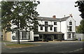
The George Inn, Frocester, Gloucestershire 2013
Image: © Ray Bird
Taken: 8 Aug 2013
0.10 miles
10
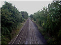
Railway line NW of Frocester
Looking north west from railway bridge on Peter's Street, NW of Frocester.
Image: © Phil Champion
Taken: 20 Aug 2005
0.11 miles