IMAGES TAKEN NEAR TO
Leonard Stanley Road, STONEHOUSE, GL10 3TE
Introduction
This page details the photographs taken nearby to Leonard Stanley Road, GL10 3TE by members of the Geograph project.
The Geograph project started in 2005 with the aim of publishing, organising and preserving representative images for every square kilometre of Great Britain, Ireland and the Isle of Man.

There are currently over 7.5m images from over14,400 individuals and you can help contribute to the project by visiting https://www.geograph.org.uk
Image Map
Images are licensed for reuse under creativecommons.org/licenses/by-sa/2.0
Notes
- Clicking on the map will re-center to the selected point.
- The higher the marker number, the further away the image location is from the centre of the postcode.
Image Listing (9 Images Found)
Images are licensed for reuse under creativecommons.org/licenses/by-sa/2.0
Image
Details
Distance
1
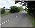
End of the 30 zone in Frocester
The 30mph speed limit on Leonard Stanley Road increases to the National Speed Limit.
Image: © Jaggery
Taken: 7 Aug 2016
0.06 miles
2
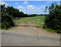
Field gates in the east of Frocester
On the north side of Leonard Stanley Road.
Image: © Jaggery
Taken: 7 Aug 2016
0.08 miles
3
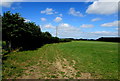
Early August in Frocester
Field viewed from these gates http://www.geograph.org.uk/photo/5173604 on August 7th 2016.
Image: © Jaggery
Taken: 7 Aug 2016
0.13 miles
4
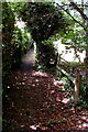
Public footpath towards Frocester Court, Frocester
On the southwest side of Leonard Stanley Road.
Image: © Jaggery
Taken: 7 Aug 2016
0.16 miles
5
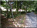
Wonky and misaligned public footpath sign, Frocester
Viewed in August 2016 when the post is non-perpendicular and points away from the public footpath http://www.geograph.org.uk/photo/5173747 on the left. There is an impenetrable barrier of trees and bushes on the opposite side of the road.
The post was perpendicular and correctly aligned in a June 2009 Google Earth Street View.
Image: © Jaggery
Taken: 7 Aug 2016
0.16 miles
6
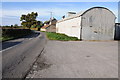
Rooftop solar panels, Frocester
On a farm building alongside Leonard Stanley Road.
Image: © Jaggery
Taken: 7 Aug 2016
0.19 miles
7
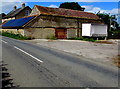
Spring Farm, Frocester
Spring Farm is on the road between Frocester and Leonard Stanley, in the foreground is a Dutch barn, one of a number of farm buildings on this site.
Image: © Philip Halling
Taken: 29 Oct 2011
0.23 miles
9
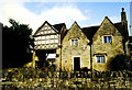
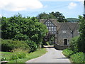
Gatehouse, Frocester Court, Frocester, Gloucestershire 2002
Image: © Ray Bird
Taken: Unknown
0.24 miles