IMAGES TAKEN NEAR TO
Stonehouse Commercial Centre, Bristol Road, STONEHOUSE, GL10 3RD
Introduction
This page details the photographs taken nearby to Stonehouse Commercial Centre, Bristol Road, GL10 3RD by members of the Geograph project.
The Geograph project started in 2005 with the aim of publishing, organising and preserving representative images for every square kilometre of Great Britain, Ireland and the Isle of Man.

There are currently over 7.5m images from over14,400 individuals and you can help contribute to the project by visiting https://www.geograph.org.uk
Image Map
Images are licensed for reuse under creativecommons.org/licenses/by-sa/2.0
Notes
- Clicking on the map will re-center to the selected point.
- The higher the marker number, the further away the image location is from the centre of the postcode.
Image Listing (141 Images Found)
Images are licensed for reuse under creativecommons.org/licenses/by-sa/2.0
Image
Details
Distance
1
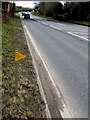
Yellow marker alongside the A419 Bristol Road, Stonehouse
Text on the Wales & West Utilities marker includes
HIGH PRESSURE GAS PIPELINE - DIAL BEFORE YOU DIG.
Image: © Jaggery
Taken: 1 Apr 2018
0.05 miles
2
Entrance to Stonehouse Commercial Centre
From the A419 Bristol Road, near the eastern end of Avenue Terrace. http://www.geograph.org.uk/photo/3825280
Image: © Jaggery
Taken: 24 Mar 2013
0.05 miles
3
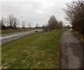
Elevated path on the north side of Bristol Road Stonehouse
Looking towards Avenue Terrace.
Image: © Jaggery
Taken: 24 Mar 2013
0.05 miles
5
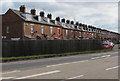
Avenue Terrace, Stonehouse
Avenue Terrace extends for 200 metres, set back from the north side of the A419 Bristol Road. The houses are not in one block. There are small gaps at intervals, which makes some of the houses semi-detached.
Image: © Jaggery
Taken: 1 Apr 2018
0.06 miles
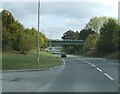
6
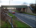
Railway bridge over Bristol Road, Stonehouse
The A419 Bristol Road passes under a bridge carrying the Bristol to Gloucester railway line. The identifier on the side wall shows Eastington Road 101m 67ch BGL. Trains on this route do not pass through Stonehouse railway station, which is on the Gloucester to Swindon route via Stroud.
Image: © Jaggery
Taken: 8 Jan 2012
0.07 miles
7
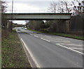
West side of Bristol Road railway bridge, Stonehouse
The A419 Bristol Road passes under a bridge carrying the two-track Bristol to Gloucester railway line.
Trains on this route do not pass through Stonehouse railway station, which is on the Gloucester to Swindon route via Stroud.
Image: © Jaggery
Taken: 1 Apr 2018
0.07 miles
8
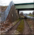
Track under a railway bridge in Stonehouse
The track alongside the A419 Bristol Road leads to this field gate. http://www.geograph.org.uk/photo/3825192
Image: © Jaggery
Taken: 24 Mar 2013
0.07 miles
9
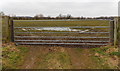
Field gate on the west side of railway lines in Stonehouse
Accessed via a track from the A419 Bristol Road.
http://www.geograph.org.uk/photo/3825199 to a view over the gate.
Image: © Jaggery
Taken: 24 Mar 2013
0.07 miles
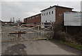
10
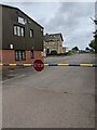
STOP barrier across a side road in Stonehouse
On the approach to C&G Services located in Station House Training Centre on the north side of the A419 Bristol Road. This area was formerly the site of Stonehouse (Bristol Road) railway station where passenger services ended in 1965.
Image: © Jaggery
Taken: 15 Aug 2021
0.08 miles