IMAGES TAKEN NEAR TO
Beards Mill, STONEHOUSE, GL10 3QY
Introduction
This page details the photographs taken nearby to Beards Mill, GL10 3QY by members of the Geograph project.
The Geograph project started in 2005 with the aim of publishing, organising and preserving representative images for every square kilometre of Great Britain, Ireland and the Isle of Man.

There are currently over 7.5m images from over14,400 individuals and you can help contribute to the project by visiting https://www.geograph.org.uk
Image Map
Images are licensed for reuse under creativecommons.org/licenses/by-sa/2.0
Notes
- Clicking on the map will re-center to the selected point.
- The higher the marker number, the further away the image location is from the centre of the postcode.
Image Listing (59 Images Found)
Images are licensed for reuse under creativecommons.org/licenses/by-sa/2.0
Image
Details
Distance
1
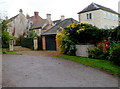
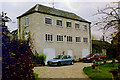
Houses near Beard's Mill, Stonehouse
The former mill, now in residential use, is on the right. http://www.geograph.org.uk/photo/333826
Image: © Jaggery
Taken: 20 Nov 2011
0.01 miles
2
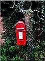
George V postbox near Beard's Mill, Stonehouse
The box is fixed to a wooden post here. http://www.geograph.org.uk/photo/3268370
Image: © Jaggery
Taken: 20 Nov 2011
0.03 miles
4
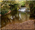
River Frome weir, Stonehouse
The weir is near the former Beard's Mill http://www.geograph.org.uk/photo/333826 now in residential use.
Image: © Jaggery
Taken: 20 Nov 2011
0.04 miles
5
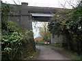
Road closed beyond a railway viaduct, Stonehouse
A temporary barrier is in place to block the road ahead during work http://www.geograph.org.uk/photo/3265209 on replacing Ocean Bridge over the Stroudwater Canal.
The viaduct carries a twin track railway line, part of the Cam & Dursley to Gloucester route. Out of shot on the right, the viaduct crosses over the River Frome.
Image: © Jaggery
Taken: 20 Nov 2011
0.06 miles
6
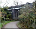
East side of a railway viaduct, Stonehouse
This part of the viaduct carries a twin track railway line, part of the Cam & Dursley to Gloucester route. Out of shot on the left, the viaduct crosses over the River Frome. There are no vehicles on the road today because this section of roadway is blocked http://www.geograph.org.uk/photo/3265347 just out of shot ahead. The road behind the camera leads to Ocean Bridge over the Stroudwater Canal. At the November 2011 date of this view, the old Ocean Bridge had been removed in preparation for the new bridge.
Image: © Jaggery
Taken: 20 Nov 2011
0.07 miles
7
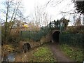
Stroudwater Canal culvert under Bristol & Gloucester Line
The original railway bridge over the canal was, if my memory serves me correctly, replaced by this culvert in the 1960s. It probably constitutes one of the most complicated, but by no means insurmountable, challenges to the complete restoration of the canal.
Image: © David Stowell
Taken: 9 Jan 2008
0.09 miles
8
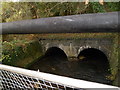
Pipeline over the River Frome, Stonehouse
Viewed from a footpath bridge SW of Ocean Bridge on the Stroudwater Canal.
Image: © Jaggery
Taken: 20 Nov 2011
0.12 miles
9
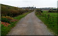
Path from Beard's Mill to Stanley Downton Sewage Treatment Works
The path runs parallel with a railway embankment on the left.
Image: © Jaggery
Taken: 20 Nov 2011
0.13 miles
10
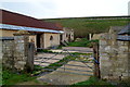
Railway embankment near Stanley Downton
Viewed from this http://www.geograph.org.uk/photo/3268401 path through buildings whose current use, if any, was not indicated.
Image: © Jaggery
Taken: 20 Nov 2011
0.13 miles