IMAGES TAKEN NEAR TO
The Green, STONEHOUSE, GL10 3JB
Introduction
This page details the photographs taken nearby to The Green, GL10 3JB by members of the Geograph project.
The Geograph project started in 2005 with the aim of publishing, organising and preserving representative images for every square kilometre of Great Britain, Ireland and the Isle of Man.

There are currently over 7.5m images from over14,400 individuals and you can help contribute to the project by visiting https://www.geograph.org.uk
Image Map
Images are licensed for reuse under creativecommons.org/licenses/by-sa/2.0
Notes
- Clicking on the map will re-center to the selected point.
- The higher the marker number, the further away the image location is from the centre of the postcode.
Image Listing (108 Images Found)
Images are licensed for reuse under creativecommons.org/licenses/by-sa/2.0
Image
Details
Distance
1
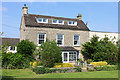
Kings Stanley
Dwelling in Kings Stanley.
Image: © Wayland Smith
Taken: 1 Jun 2014
0.00 miles
2
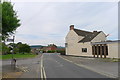
High Street, King's Stanley
The Kings Head sadly closed; but thankfully a beer may be had from the nearby convenience store. Buses to Stroud from the stop opposite the pub
Image: © Tim Heaton
Taken: 6 Jul 2017
0.01 miles
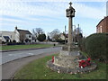
3
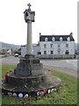
King's Stanley war memorial
With the King's Head pub in the background, the memorial stands at the junction of Church Street, Broad Street and High Street.
Image: © Neil Owen
Taken: 7 Feb 2023
0.02 miles
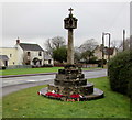
4
Light at the top
King's Stanley war memorial features an unusual top: the openings are there to allow a light to shine along the roads. The light is no longer used and the memorial was repositioned slightly in 1983 to a spot at the side of the roads. Grade II listed.
Image: © Neil Owen
Taken: 7 Feb 2023
0.02 miles
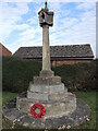
5
Moved from the middle of the road
King's Stanley war memorial used to stand right at the road junction originally, but was replocated in 1983 to this spot just a few metres away.
The memorial dates from about 1920 and contains tributes to the twenty-five men of WWI and the fourteen of WWII that fell in battle. It was renovated in 2003 with the help of grant aid from War Memorials Trust. Grade II listed.
Image: © Neil Owen
Taken: 7 Feb 2023
0.02 miles
6
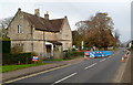
Road works, Church Street, King's Stanley
A red white and blue temporary notice on the pavement states that Morgan Sindall
is carrying out the work on behalf of Severn Trent Water.
Image: © Jaggery
Taken: 20 Nov 2011
0.03 miles
7
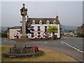
Kings' Stanley: War Memorial and King's Head
On the green at King's Stanley, with the High Street on the right.
Image: © Derek Harper
Taken: 5 Jul 2006
0.03 miles
8
King's Stanley War Memorial
The Cotswold limestone memorial, of unusually elaborate form, with a four-sided lantern head which served as a light, was erected c1920 in the middle of the road at the junction of Broad Street, Church Street and High Street. After the Second World War, the Memorial was altered to also commemorate the men of the village who lost their lives in that conflict. In 1983, to minimise the risk of damage from traffic, the Memorial was moved a short distance to its present roadside location. Grade II listed in 2016.
Image: © Jaggery
Taken: 22 Dec 2017
0.03 miles
9
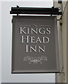
Kings Head Inn name sign, King's Stanley
Located on the left here https://www.geograph.org.uk/photo/5633325 viewed in December 2017.
A sign depicting King Richard I http://www.geograph.org.uk/photo/2702248 was here in November 2011.
Image: © Jaggery
Taken: 22 Dec 2017
0.03 miles
10
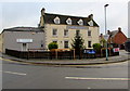
Kings Head, King's Stanley
Pub on the corner of High Street and Broad Street.
Nera Coffee House on the left is alongside Broad Street.
Built in 1820, the Kings Head was Grade II listed in 1987.
Image: © Jaggery
Taken: 22 Dec 2017
0.03 miles