IMAGES TAKEN NEAR TO
Colethrop, STONEHOUSE, GL10 3EN
Introduction
This page details the photographs taken nearby to GL10 3EN by members of the Geograph project.
The Geograph project started in 2005 with the aim of publishing, organising and preserving representative images for every square kilometre of Great Britain, Ireland and the Isle of Man.

There are currently over 7.5m images from over14,400 individuals and you can help contribute to the project by visiting https://www.geograph.org.uk
Image Map
Images are licensed for reuse under creativecommons.org/licenses/by-sa/2.0
Notes
- Clicking on the map will re-center to the selected point.
- The higher the marker number, the further away the image location is from the centre of the postcode.
Image Listing (6 Images Found)
Images are licensed for reuse under creativecommons.org/licenses/by-sa/2.0
Image
Details
Distance
1
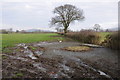
Muddy field corner
The corner of this field is muddy as a result of hay feeder being located here though it has been removed.
Image: © Philip Halling
Taken: 16 Feb 2013
0.10 miles
2
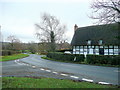
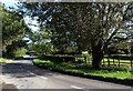
Colethrop
A tiny hamlet midway between Haresfield and Harescombe.
Image: © Jonathan Billinger
Taken: 21 Dec 2011
0.15 miles
3
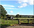
Small field, Colethrop, Gloucestershire
Image: © nick macneill
Taken: 14 Oct 2012
0.19 miles
4
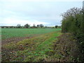
Field edge near Colethrop
A public path follows the hedge north-east towards Chambers Farm and Brookthorpe.
Image: © Jonathan Billinger
Taken: 21 Dec 2011
0.20 miles
6
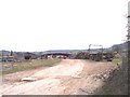
Colethorpe Court Farm
Looking up the track into the timber yard and farm buildings.
Image: © Bob Embleton
Taken: 13 Mar 2006
0.25 miles