IMAGES TAKEN NEAR TO
Standish, STONEHOUSE, GL10 3DQ
Introduction
This page details the photographs taken nearby to GL10 3DQ by members of the Geograph project.
The Geograph project started in 2005 with the aim of publishing, organising and preserving representative images for every square kilometre of Great Britain, Ireland and the Isle of Man.

There are currently over 7.5m images from over14,400 individuals and you can help contribute to the project by visiting https://www.geograph.org.uk
Image Map
Images are licensed for reuse under creativecommons.org/licenses/by-sa/2.0
Notes
- Clicking on the map will re-center to the selected point.
- The higher the marker number, the further away the image location is from the centre of the postcode.
Image Listing (3 Images Found)
Images are licensed for reuse under creativecommons.org/licenses/by-sa/2.0
Image
Details
Distance
1
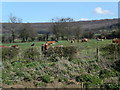
Farmland below Standish Woods
The farmland past Standish village starts to rise towards Standish woods. The Cotswold Way path runs through the woods.
Image: © Vincent Jones
Taken: 5 Apr 2006
0.14 miles
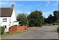
3

Vinegar Hill
Vinegar hill lies on the lower slopes of Haresfield Beacon where the Cotswold Way path travels by.
Image: © Vincent Jones
Taken: 5 Apr 2006
0.25 miles