IMAGES TAKEN NEAR TO
Standish, STONEHOUSE, GL10 3BZ
Introduction
This page details the photographs taken nearby to GL10 3BZ by members of the Geograph project.
The Geograph project started in 2005 with the aim of publishing, organising and preserving representative images for every square kilometre of Great Britain, Ireland and the Isle of Man.

There are currently over 7.5m images from over14,400 individuals and you can help contribute to the project by visiting https://www.geograph.org.uk
Image Map
Images are licensed for reuse under creativecommons.org/licenses/by-sa/2.0
Notes
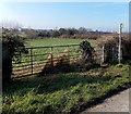
- Clicking on the map will re-center to the selected point.
- The higher the marker number, the further away the image location is from the centre of the postcode.
Image Listing (22 Images Found)
Images are licensed for reuse under creativecommons.org/licenses/by-sa/2.0
Image
Details
Distance
1
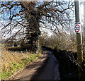
Check speed 20 near Moreton Hill Farm, Standish
Is the sign on a post an official one?
Image: © Jaggery
Taken: 17 Feb 2013
0.04 miles
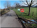
2
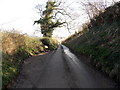
Passing place near Moreton Hill Farm, Standish
This is one of several passing places along a narrow road.
Image: © Jaggery
Taken: 17 Feb 2013
0.07 miles
3
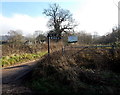
Kilometre signpost at a road junction in Standish
Viewed from Horsemarling Lane. The signpost arms show distances in kilometres only. Continue along Horsemarling Lane for Stonehouse (1km) or take the other road towards Doverow Hill (1km) and King's Stanley (4km).
Image: © Jaggery
Taken: 17 Feb 2013
0.07 miles
4
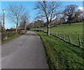
Tree-lined access road to Standish Hospital
There is a distinctive style of concrete lamppost on the left. The lamp has survived, unlike several smashed examples nearby.
Image: © Jaggery
Taken: 17 Feb 2013
0.07 miles
5
Beware pedestrians on the access road to Standish Hospital, Standish
This sign could be interpreted in two ways.
Presumably it is intended to tell vehicle drivers to beware of pedestrians in the roadway.
Or it could be telling pedestrians to beware, but of what? Dangerous creatures lurking in the grounds?
Image: © Jaggery
Taken: 17 Feb 2013
0.07 miles
6
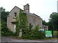
Standish Lodge
This was the lodge to the former Standish House which became a hospital and is now, as the notice says, for sale. Smart rusticated quoins. Taken from Horsemarling Lane.
Image: © Derek Harper
Taken: 5 Jul 2006
0.08 miles
7
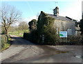
Standish Lodge, Standish
This building at the Horsemarling Lane corner of the access road to Standish Hospital
has deteriorated since this view http://www.geograph.org.uk/photo/197382 taken in 2006.
Image: © Jaggery
Taken: 17 Feb 2013
0.08 miles
8
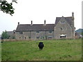
Welch's Farm, Standish
C16-C17 farmhouse (and its dark guardian) - details from when it was offered for sale by Gloucestershire County Council in 2004 at http://www.gloucestershire.gov.uk/media/adobe_acrobat/t/o/welchs_farm.pdf . Seen from a diverted footpath past trees laden with mistletoe.
Image: © Derek Harper
Taken: 5 Jul 2006
0.13 miles
9
Kissing gate access to a public footpath, Horsemarling Lane, Standish
Signs point left and right to public footpaths on both sides of Horsemarling Lane.
Image: © Jaggery
Taken: 17 Feb 2013
0.13 miles
10
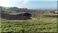
Farm buildings, Moreton Hill Farm, Standish
The town of Stonehouse is in the distance.
Image: © Jaggery
Taken: 17 Feb 2013
0.14 miles