IMAGES TAKEN NEAR TO
Alkerton, STONEHOUSE, GL10 3AF
Introduction
This page details the photographs taken nearby to Alkerton, GL10 3AF by members of the Geograph project.
The Geograph project started in 2005 with the aim of publishing, organising and preserving representative images for every square kilometre of Great Britain, Ireland and the Isle of Man.

There are currently over 7.5m images from over14,400 individuals and you can help contribute to the project by visiting https://www.geograph.org.uk
Image Map
Images are licensed for reuse under creativecommons.org/licenses/by-sa/2.0
Notes
- Clicking on the map will re-center to the selected point.
- The higher the marker number, the further away the image location is from the centre of the postcode.
Image Listing (42 Images Found)
Images are licensed for reuse under creativecommons.org/licenses/by-sa/2.0
Image
Details
Distance
1

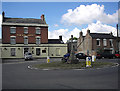
Eastington abattoir
Bath Road premises of J.Broomhall. The butcher's shop http://www.geograph.org.uk/photo/4049205 is out of shot on the right.
The label over the door on the left is Lairage. The label over the other door is Hide/Skin.
Image: © Jaggery
Taken: 29 Jun 2014
0.03 miles
2

J Broomhall butchers shop and abattoir, Eastington
Viewed across Bath Road. The shop is on the right. The abattoir is set back from the left side of the view.
Image: © Jaggery
Taken: 29 Jun 2014
0.04 miles
3
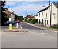
Alkerton Road, Eastington
Looking to the NW along Alkerton Road from this https://www.geograph.org.uk/photo/5835784 roundabout.
Image: © Jaggery
Taken: 7 Aug 2016
0.04 miles
4

Eastington Methodist Church
Viewed across Bath Road in Alkerton, Eastington. The church opened in July 1975 in the converted former church schoolroom. It replaced its Victorian predecessor dating from 1870. The roof of the old building had become vulnerable to storm damage, and the church was now too big for the size of the congregation. The last service in the old building was held on January 19th 1975.
Image: © Jaggery
Taken: 29 Jun 2014
0.05 miles
5
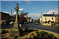
Roundabout at Alkerton, Eastington
At the junction of Alkerton Road and Bath Road. I don't know anything about the stone cross, but it clearly pre-dates the roundabout. The 'King's Head' on the south side of the junction is a late-18th or early-19th-century brick house with a cornice and a parapet, a doorway with a fan-light, and a porch with Doric columns; it was a public house by 1834.
Image: © Phil Champion
Taken: 20 Aug 2005
0.08 miles
6

Green Farm, Eastington
In the Alkerton area of the village.
Image: © Jaggery
Taken: 29 Jun 2014
0.08 miles
8

The Hair & Beauty House, Eastington
The business is in the centre of the view, located opposite
the Alkerton Cross on the corner of Alkerton Road and Bath Road.
Image: © Jaggery
Taken: 29 Jun 2014
0.09 miles
10

Entrance gates on the road to Eastington Community Centre
This way to the community centre http://www.geograph.org.uk/photo/4049248 and playing fields (the Owen Harris Memorial Ground).
Image: © Jaggery
Taken: 29 Jun 2014
0.09 miles