IMAGES TAKEN NEAR TO
Kestrel Court, STONEHOUSE, GL10 2RE
Introduction
This page details the photographs taken nearby to Kestrel Court, GL10 2RE by members of the Geograph project.
The Geograph project started in 2005 with the aim of publishing, organising and preserving representative images for every square kilometre of Great Britain, Ireland and the Isle of Man.

There are currently over 7.5m images from over14,400 individuals and you can help contribute to the project by visiting https://www.geograph.org.uk
Image Map
Images are licensed for reuse under creativecommons.org/licenses/by-sa/2.0
Notes
- Clicking on the map will re-center to the selected point.
- The higher the marker number, the further away the image location is from the centre of the postcode.
Image Listing (861 Images Found)
Images are licensed for reuse under creativecommons.org/licenses/by-sa/2.0
Image
Details
Distance
1
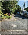
Towards the upper end of Verney Road, Stonehouse, Gloucestershire
The road ahead is not a through route for motor vehicles.
Image: © Jaggery
Taken: 4 Jun 2023
0.02 miles
2
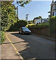
Upper end of Verney Road, Stonehouse, Gloucestershire
The car is parked at the end of the roadway.
Walkers and cyclists can use a path to Bramble Lane.
Image: © Jaggery
Taken: 4 Jun 2023
0.02 miles
3
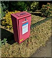
Litter bin 180, Verney Road, Stonehouse, Gloucestershire
In June 2023 text on the Stroud District Council bin located here https://www.geograph.org.uk/photo/7502638 includes
"LITTER IS UNSIGHTLY
BAG IT AND BIN IT
LITTERING FINE £75"
Image: © Jaggery
Taken: 4 Jun 2023
0.02 miles
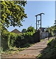
4
Wonky public footpath direction sign, Verney Road, Stonehouse
Not perpendicular in June 2023, the sign points towards this https://www.geograph.org.uk/photo/7502639 public footpath.
Image: © Jaggery
Taken: 4 Jun 2023
0.02 miles
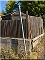
5
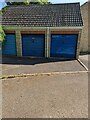
Three lockup garages at the eastern edge of Stonehouse
At the southern end of Bramble Lane.
Image: © Jaggery
Taken: 4 Jun 2023
0.03 miles
6
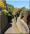
Public footpath, Stonehouse, Gloucestershire
Descending from the west side of Verney Road.
Image: © Jaggery
Taken: 4 Jun 2023
0.03 miles
7
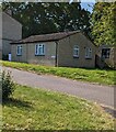
Starling Court bungalow, Stonehouse, Gloucestershire
Viewed from Paddock Rise.
Image: © Jaggery
Taken: 4 Jun 2023
0.03 miles
8
Line spur pole, Stonehouse, Gloucestershire
Located at the eastern edge of Stonehouse, part of National Grid's electricity supply infrastructure.
Image: © Jaggery
Taken: 4 Jun 2023
0.03 miles
9
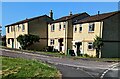
Paddock Rise houses, Stonehouse, Gloucestershire
Viewed from the corner of Meadow Road. Paddock Rise leads to Hazelwood, Kestrel Court and Starling Court.
Image: © Jaggery
Taken: 4 Jun 2023
0.04 miles
10
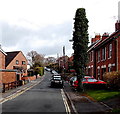
Verney Road, Stonehouse
Looking NNE from the Upper Queens Road end, near an entrance http://www.geograph.org.uk/photo/3899565 to Stonehouse railway station.
Image: © Jaggery
Taken: 23 Mar 2014
0.04 miles