IMAGES TAKEN NEAR TO
Ryelands Road, STONEHOUSE, GL10 2PQ
Introduction
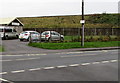
This page details the photographs taken nearby to Ryelands Road, GL10 2PQ by members of the Geograph project.
The Geograph project started in 2005 with the aim of publishing, organising and preserving representative images for every square kilometre of Great Britain, Ireland and the Isle of Man.

There are currently over 7.5m images from over14,400 individuals and you can help contribute to the project by visiting https://www.geograph.org.uk
Image Map
Images are licensed for reuse under creativecommons.org/licenses/by-sa/2.0
Notes
- Clicking on the map will re-center to the selected point.
- The higher the marker number, the further away the image location is from the centre of the postcode.
Image Listing (407 Images Found)
Images are licensed for reuse under creativecommons.org/licenses/by-sa/2.0
Image
Details
Distance
1
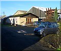
Oldends Lane railway embankment, Stonehouse
The railway here is 4 metres above road level. Stonehouse Scout Hall http://www.geograph.org.uk/photo/3250543 is on the left.
This http://www.geograph.org.uk/photo/3250401 railway bridge is a few metres out of shot on the right.
Image: © Jaggery
Taken: 13 Dec 2015
0.10 miles
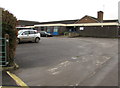
2

The Lawns, Stonehouse
Cul-de-sac extending for 70 metres from the west side of the B4008.
Image: © Jaggery
Taken: 13 Dec 2015
0.10 miles
3
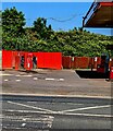
Stonehouse Autoparts, Stonehouse
At 2 Gloucester Road, part of Bridge Service Station. http://www.geograph.org.uk/photo/4785378
The service station shop is on the right.
Image: © Jaggery
Taken: 13 Dec 2015
0.10 miles
4
Stonehouse Scout Hall
The 1st Stonehouse Scout Group hall is on the south side of Oldends Lane,
at the edge of a railway embankment near this bridge. http://www.geograph.org.uk/photo/3250401
Image: © Jaggery
Taken: 18 Dec 2011
0.10 miles
5
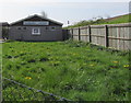
Scout Hall in Stonehouse
The northwest side of this https://www.geograph.org.uk/photo/3250543 scout hall.
The name on the wall in April 2018 is 1ST STONEHOUSE SCOUT GROUP.
A railway embankment is behind the fence.
Image: © Jaggery
Taken: 22 Apr 2018
0.10 miles
6
Stonehouse Baptist Church
Stonehouse Baptist Church dates its origins to the early 1900s. Its original building, in Woodcock Lane, was often referred to informally as a tin tabernacle. The current building, seen here, has been the church's location since 1970. It is set back 25 metres from the west side of Gloucester Road.
Image: © Jaggery
Taken: 18 Dec 2011
0.10 miles
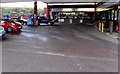
7
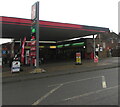
Into the shadows, Gloucester Road, Stonehouse
Viewed across the B4008 on a gloomy, rainy day in December 2020.
A small Londis shop is part of Bridge Service Station at 2 Gloucester Road.
An InstaVolt electric vehicle charging point https://www.geograph.org.uk/photo/6701607 is on the right.
Image: © Jaggery
Taken: 6 Dec 2020
0.10 miles
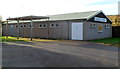
8
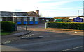
The Shrubberies School, Stonehouse
Located in Oldends Lane, The Shrubberies is an SEN (special educational needs) school for pupils who have SEN from causes such as profound and multiple learning difficulties or autistic spectrum disorders. Most of its pupils are boys.
Image: © Jaggery
Taken: 18 Dec 2011
0.10 miles
9
Main entrance to the Shrubberies School, Stonehouse
From Oldends Lane. The notice on the wall states that all visitors must report to reception (entrance on left side of notice). The Shrubberies is a special educational needs (SEN) school for pupils who have SEN from causes such as profound and multiple learning difficulties or autistic spectrum disorders. Most of its pupils are boys.
Image: © Jaggery
Taken: 13 Dec 2015
0.10 miles
10
Jet Wash, Gloucester Road, Stonehouse
On the left. Part of the Texaco filling station canopy is on the right.
Image: © Jaggery
Taken: 4 Jun 2023
0.10 miles