IMAGES TAKEN NEAR TO
Juniper Way, STONEHOUSE, GL10 2ED
Introduction
This page details the photographs taken nearby to Juniper Way, GL10 2ED by members of the Geograph project.
The Geograph project started in 2005 with the aim of publishing, organising and preserving representative images for every square kilometre of Great Britain, Ireland and the Isle of Man.

There are currently over 7.5m images from over14,400 individuals and you can help contribute to the project by visiting https://www.geograph.org.uk
Image Map
Images are licensed for reuse under creativecommons.org/licenses/by-sa/2.0
Notes
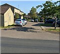
- Clicking on the map will re-center to the selected point.
- The higher the marker number, the further away the image location is from the centre of the postcode.
Image Listing (202 Images Found)
Images are licensed for reuse under creativecommons.org/licenses/by-sa/2.0
Image
Details
Distance
1
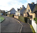
Cotswold Green houses, Stonehouse
Cotswold Green consists of two roughly parallel arms about 50 metres apart, separated by a green.
The houses are on the west side of the western arm and the east side of the eastern arm.
This view is of the western arm.
Image: © Jaggery
Taken: 18 Dec 2011
0.07 miles
2
Blackbird Court, Stonehouse, Gloucestershire
Cul-de-sac on the north side of Bramble Lane at the eastern edge of Stonehouse.
Image: © Jaggery
Taken: 4 Jun 2023
0.08 miles
3

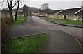
Kimmins Road, Stonehouse
Viewed from the playing field end looking towards Woodcock Lane.
Image: © Jaggery
Taken: 18 Dec 2011
0.09 miles
4
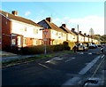
Houses on the north side of Woodcock Lane, Stonehouse
Viewed from the edge of the mini-roundabout at the King's Road junction. A thin layer of frost remains on surfaces not yet reached by direct sunshine at 10.20am on a day in mid December.
Image: © Jaggery
Taken: 18 Dec 2011
0.09 miles
5
Sherborne Close, Stonehouse
Viewed from the western end of Sherborne Close looking towards Osprey Drive.
Image: © Jaggery
Taken: 13 Dec 2015
0.10 miles
6
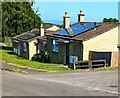
Rooftop solar panels, Bramble Lane, Stonehouse, Gloucestershire
On bungalows located between Blackbird Court and Meadow Road.
Image: © Jaggery
Taken: 4 Jun 2023
0.10 miles
7
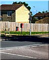
Queen Elizabeth II postbox, Meadow Road, Stonehouse
Located here. https://www.geograph.org.uk/photo/7507718
Image: © Jaggery
Taken: 4 Jun 2023
0.10 miles
8
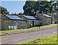
Bungalows with rooftop solar panels, Stonehouse, Gloucestershire
On the north side of Bramble Lane.
Image: © Jaggery
Taken: 4 Jun 2023
0.11 miles
9
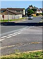
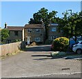
Junction of Meadow Road and Bramble Lane, Stonehouse
From the right (east), Bramble Lane joins Meadow Road.
Image: © Jaggery
Taken: 4 Jun 2023
0.11 miles
10
Goldcrest Court, Stonehouse, Gloucestershire
Cul-de-sac on the north side of Meadow Road.
Image: © Jaggery
Taken: 4 Jun 2023
0.11 miles