IMAGES TAKEN NEAR TO
Oldends Lane, STONEHOUSE, GL10 2DG
Introduction
This page details the photographs taken nearby to Oldends Lane, GL10 2DG by members of the Geograph project.
The Geograph project started in 2005 with the aim of publishing, organising and preserving representative images for every square kilometre of Great Britain, Ireland and the Isle of Man.

There are currently over 7.5m images from over14,400 individuals and you can help contribute to the project by visiting https://www.geograph.org.uk
Image Map
Images are licensed for reuse under creativecommons.org/licenses/by-sa/2.0
Notes
- Clicking on the map will re-center to the selected point.
- The higher the marker number, the further away the image location is from the centre of the postcode.
Image Listing (84 Images Found)
Images are licensed for reuse under creativecommons.org/licenses/by-sa/2.0
Image
Details
Distance
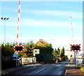
1
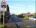
Warning of level crossing ahead, Oldends Lane, Stonehouse
The level crossing http://www.geograph.org.uk/photo/3250640 is about 160 metres ahead.
Image: © Jaggery
Taken: 18 Dec 2011
0.01 miles
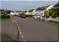
2
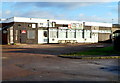
Magpies Sports and Social Club, Stonehouse
Viewed across Oldends Lane. The building is at the southern edge of Magpies Stadium, the home ground of Stonehouse Town Football Club who play in the Gloucestershire Northern Senior League. The club's home colours are black shorts and black and white striped shirts, hence the nickname Magpies.
Image: © Jaggery
Taken: 18 Dec 2011
0.02 miles
3
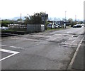
East across Oldends Level Crossing, Stonehouse
Ahead along Oldends Lane for the B4008 Gloucester Road.
Image: © Jaggery
Taken: 22 Apr 2018
0.03 miles
4
Eastern approach to Oldends Level Crossing, Stonehouse
Looking west along Oldends Lane. On this https://www.geograph.org.uk/photo/6428745 bridge, another railway crosses Oldends Lane 300 metres behind the camera.
Image: © Jaggery
Taken: 22 Apr 2018
0.03 miles
5
West along Midland Road, Stonehouse
Viewed from the Severn Road junction. The course of Midland Road turns through 90 degrees in the background.
Image: © Jaggery
Taken: 22 Apr 2018
0.03 miles
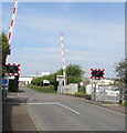
6
Oldends Lane level crossing, Stonehouse
The railway crossing the road is part of the route from Cam & Dursley station to Gloucester station. Trains on this route do not call at the nearby Stonehouse station which is on another route, the one from Swindon to Gloucester via Kemble and Stroud. These two routes meet about a kilometre north of this level crossing.
Image: © Jaggery
Taken: 18 Dec 2011
0.03 miles
7
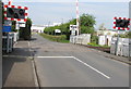
West across Oldends Level Crossing, Stonehouse
Crossing at the intersection of Oldends Lane and the railway line between
Cam & Dursley station to the southwest and Gloucester station to the north.
Image: © Jaggery
Taken: 22 Apr 2018
0.03 miles
8
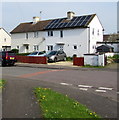
Rooftop solar panels, Midland Road, Stonehouse
Viewed from the corner of Severn Road.
Image: © Jaggery
Taken: 22 Apr 2018
0.04 miles
9
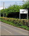
Oldends Lane direction sign, Stonehouse
At the roundabout ahead, turn right for Stroudwater Business Park, left for all other routes.
Image: © Jaggery
Taken: 22 Apr 2018
0.05 miles
10
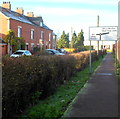
Oldends Lane footpath, Stonehouse
North of the level crossing http://www.geograph.org.uk/photo/3250640 there are no pavements alongside Oldends Lane.
Instead there is this footpath, separated from the roadway by a hedge.
Image: © Jaggery
Taken: 18 Dec 2011
0.06 miles