IMAGES TAKEN NEAR TO
HELENSBURGH, G84 9QG
Introduction
This page details the photographs taken nearby to G84 9QG by members of the Geograph project.
The Geograph project started in 2005 with the aim of publishing, organising and preserving representative images for every square kilometre of Great Britain, Ireland and the Isle of Man.

There are currently over 7.5m images from over14,400 individuals and you can help contribute to the project by visiting https://www.geograph.org.uk
Image Map
Images are licensed for reuse under creativecommons.org/licenses/by-sa/2.0
Notes
- Clicking on the map will re-center to the selected point.
- The higher the marker number, the further away the image location is from the centre of the postcode.
Image Listing (17 Images Found)
Images are licensed for reuse under creativecommons.org/licenses/by-sa/2.0
Image
Details
Distance
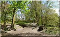
1
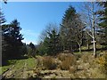
Milburn Wood
The small sign on the right confirms the name of the woods.
Image: © Lairich Rig
Taken: 21 Apr 2016
0.11 miles
2
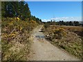
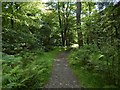
Path at Milburn Wood
The path is marked on the 1:25000 map. A few metres ahead is some water, where the path is crossed by the burn that is shown in Image and Image
Image: © Lairich Rig
Taken: 21 Apr 2016
0.12 miles
3
Path in Milburn Wood
Image: © Lairich Rig
Taken: 21 Apr 2016
0.13 miles
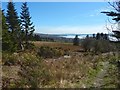
4
Plantation beside Highlandman's Road
Highlandman's Road is a path that is on the right, following the edge of the woods; as shown on the map, it is parallel to the view direction of this picture.
Image: © Lairich Rig
Taken: 21 Apr 2016
0.18 miles
5
Footpath in Duchess Wood
For a view of the footbridge from the side, see Image
Image: © Lairich Rig
Taken: 15 May 2013
0.19 miles
6
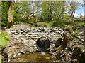
Footbridge in Duchess Wood
The footbridge is on a Image The present view illustrates that the line of the West Highland Railway is nearby, at the edge of the woods.
Image: © Lairich Rig
Taken: 15 May 2013
0.19 miles
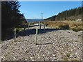
7
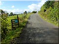
Track to Ardencaple Farm
The photograph was taken from the point where a footpath meets this farm track, as shown in Image
The footpath through the woods is part of a route to Duchess Wood. That route subsequently follows part of this farm track – not along the section shown in the present photograph (see the sign), but, rather, in the opposite direction: Image
Image: © Lairich Rig
Taken: 19 Sep 2012
0.20 miles
8
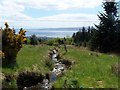
Rhu - Helensburgh, Hill House Track, unnamed burn
Burn flows through Helensburgh to River Clyde.
Image: © william craig
Taken: 2 Jun 2006
0.21 miles
9
Path in Ardencaple Wood
About 100 metres ahead, it meets a Image
Image: © Lairich Rig
Taken: 8 Aug 2017
0.21 miles
10
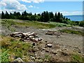
Cleared area in Milburn Wood
Milburn Wood is the central part of the northern half of Ardencaple Wood. This area has recently been cleared. The picture was taken from the adjacent path, Highlandman's Road.
Image: © Lairich Rig
Taken: 9 Jul 2014
0.21 miles