IMAGES TAKEN NEAR TO
Duchess Park, HELENSBURGH, G84 9PY
Introduction
This page details the photographs taken nearby to Duchess Park, G84 9PY by members of the Geograph project.
The Geograph project started in 2005 with the aim of publishing, organising and preserving representative images for every square kilometre of Great Britain, Ireland and the Isle of Man.

There are currently over 7.5m images from over14,400 individuals and you can help contribute to the project by visiting https://www.geograph.org.uk
Image Map
Images are licensed for reuse under creativecommons.org/licenses/by-sa/2.0
Notes
- Clicking on the map will re-center to the selected point.
- The higher the marker number, the further away the image location is from the centre of the postcode.
Image Listing (36 Images Found)
Images are licensed for reuse under creativecommons.org/licenses/by-sa/2.0
Image
Details
Distance
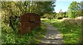
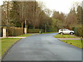
2
Duchess Wood
The footpath shown here is a continuation of the one that is shown in Image
Image: © Lairich Rig
Taken: 26 Oct 2011
0.09 miles
3
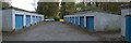
Garages for Strathclyde Court
Strathclyde Court is a housing development at the western end of Millig Street. Those buildings are located behind the garages on the right, but are largely hidden by trees.
A footpath through Duchess Wood, a Local Nature Reserve, passes through this area by means of the gaps (foreground, left and right) between the garage blocks. This end of Millig Street therefore serves as one of the access points to Duchess Park.
For the parts of the footpath that lie to the south and north, respectively, of these garages, see Image and Image
Image: © Lairich Rig
Taken: 26 Oct 2011
0.09 miles
4
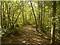
Path through Duchess Wood
See also Image; the present photograph was taken from about 50 metres further along the path.
Image: © Lairich Rig
Taken: 21 Sep 2012
0.14 miles
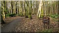
5
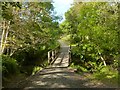
Footbridge in Duchess Wood
Near this point there is a three-way footpath junction; for one of the paths that lead here, see Image From the junction, a second path (Image) heads roughly SSE, leaving Duchess Wood at the place shown in an earlier photograph by William Craig: Image
A third path, which heads WNW, is shown in the present photograph; for a view from beyond the little footbridge, see Image
Image: © Lairich Rig
Taken: 21 Sep 2012
0.15 miles
6
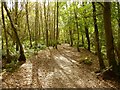
Path through Duchess Wood
See Image and Image for views from further along the same route. At the time of writing, this path is not included on OS maps, but others nearby are.
Image: © Lairich Rig
Taken: 21 Sep 2012
0.16 miles
7
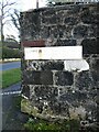
Old and new street nameplates
At the corner of Upper Sutherland Street and Millig Street. The cast iron street nameplate above (for Sutherland St) is still as legible as when it was made (and would be more so if painted). The newer modern street name sign (for Upper Sutherland Street) has faded so much it is almost illegible.
Image: © Richard Sutcliffe
Taken: 27 Jan 2022
0.17 miles
8
Path in Duchess Wood
The photograph was taken just a short distance further along the path that is shown in Image
The structure on the left is an old railway wagon, easily recognisable as such because I had elsewhere passed one very much like it, although slightly more intact, just six months earlier (it is shown in another contributor's photograph: Image).
For the area ahead, see Image
Image: © Lairich Rig
Taken: 21 Sep 2012
0.19 miles
10
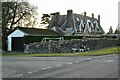
Villa on Suffolk Street
Category B listed villa http://portal.historicenvironment.scot/designation/LB34881 dating from 1864, built for Charles Hamilton.
Image: © Richard Sutcliffe
Taken: 27 Jan 2022
0.20 miles