IMAGES TAKEN NEAR TO
Camperdown Court, HELENSBURGH, G84 9HH
Introduction
This page details the photographs taken nearby to Camperdown Court, G84 9HH by members of the Geograph project.
The Geograph project started in 2005 with the aim of publishing, organising and preserving representative images for every square kilometre of Great Britain, Ireland and the Isle of Man.

There are currently over 7.5m images from over14,400 individuals and you can help contribute to the project by visiting https://www.geograph.org.uk
Image Map
Images are licensed for reuse under creativecommons.org/licenses/by-sa/2.0
Notes
- Clicking on the map will re-center to the selected point.
- The higher the marker number, the further away the image location is from the centre of the postcode.
Image Listing (21 Images Found)
Images are licensed for reuse under creativecommons.org/licenses/by-sa/2.0
Image
Details
Distance
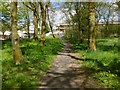
1
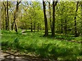
Woodland paths in Churchill Estate
This area of woodland lies within the housing estate (compare Image); that is why lamp posts can be seen beside the paths.
Image: © Lairich Rig
Taken: 22 May 2013
0.06 miles
2
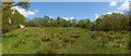
Grassy space near Helensburgh
This area is between the houses of Churchill Estate (background left) and the wooded Garrawy Glen, which is behind a metal fence on the right.
Image: © Lairich Rig
Taken: 22 May 2013
0.07 miles
3
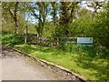
Entrance to Garrawy Glen
The entrance (also shown in an earlier picture – Image) is beside Winston Road (that road is shown in Image).
For a view back from the other side of the gate, see Image
Image: © Lairich Rig
Taken: 22 May 2013
0.09 miles
4
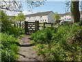
Leaving Garrawy Glen
For views of the gate from the other side, see Image and Image
For the road in the background, see Image
Image: © Lairich Rig
Taken: 22 May 2013
0.09 miles
5
Woodland path in Churchill Estate
The properties in the background are on a street called Hardy Hill; they were being refurbished when this picture was taken.
See also Image
Image: © Lairich Rig
Taken: 22 May 2013
0.10 miles
6
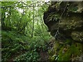
Rock face in Garrawy Glen
The same feature is shown, in the opposite direction, in Image The rock face is on the western side of Garrawy Glen.
Image: © Lairich Rig
Taken: 17 Aug 2016
0.11 miles
7
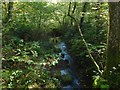
Burn in Garrawy Glen
This view downstream is from a Image
Image: © Lairich Rig
Taken: 8 Oct 2015
0.11 miles
8
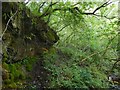
Rock face in Garrawy Glen
The burn is on the right (east), but the picture is intended to show the rock face on the western side of the glen. The waterfall that is marked on the 1:25000 map is just upstream, but was not well seen from here on account of the dense tree cover.
For a view in the opposite direction, see Image
Image: © Lairich Rig
Taken: 17 Aug 2016
0.11 miles
9
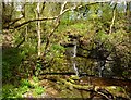
Waterfall in Garrawy Glen
This is the waterfall that is marked on the 1:25000 map. On this occasion, the flow was no more than a trickle; the weather had been drier than usual.
Image: © Lairich Rig
Taken: 22 May 2013
0.12 miles
10
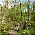
Footbridge in Garrawy Glen
The footbridge leads over the burn that flows through the glen; further upstream, the glen is steeper: Image
The waterfall that is marked on the 1:25000 OS map is only a short distance downstream from this bridge: Image
Image: © Lairich Rig
Taken: 22 May 2013
0.13 miles