IMAGES TAKEN NEAR TO
HELENSBURGH, G84 9ED
Introduction
This page details the photographs taken nearby to G84 9ED by members of the Geograph project.
The Geograph project started in 2005 with the aim of publishing, organising and preserving representative images for every square kilometre of Great Britain, Ireland and the Isle of Man.

There are currently over 7.5m images from over14,400 individuals and you can help contribute to the project by visiting https://www.geograph.org.uk
Image Map
Images are licensed for reuse under creativecommons.org/licenses/by-sa/2.0
Notes
- Clicking on the map will re-center to the selected point.
- The higher the marker number, the further away the image location is from the centre of the postcode.
Image Listing (8 Images Found)
Images are licensed for reuse under creativecommons.org/licenses/by-sa/2.0
Image
Details
Distance
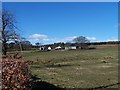
2
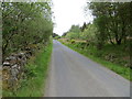
Road beside Highfields Muir
Looking north-westward.
Image: © Peter Wood
Taken: 25 May 2019
0.10 miles
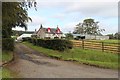
4
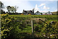
Highfields Farm
View of Highfields Farm in Glen Fruin, the road is single track most of the way between the Crosskeys Roundabout and Faslane Naval Base.
Image: © George Rankin
Taken: 15 May 2007
0.14 miles
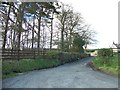
6
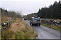
4 x 4 convoy, Glen Fruin
A shoot on the move in all likelihood.
Image: © Richard Webb
Taken: 12 Dec 2015
0.16 miles
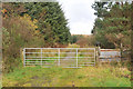
8
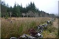
Highfields Muir
Conifer plantation in Glen Fruin.
Image: © Richard Webb
Taken: 12 Dec 2015
0.18 miles