IMAGES TAKEN NEAR TO
HELENSBURGH, G84 9EB
Introduction
This page details the photographs taken nearby to G84 9EB by members of the Geograph project.
The Geograph project started in 2005 with the aim of publishing, organising and preserving representative images for every square kilometre of Great Britain, Ireland and the Isle of Man.

There are currently over 7.5m images from over14,400 individuals and you can help contribute to the project by visiting https://www.geograph.org.uk
Image Map
Images are licensed for reuse under creativecommons.org/licenses/by-sa/2.0
Notes
- Clicking on the map will re-center to the selected point.
- The higher the marker number, the further away the image location is from the centre of the postcode.
Image Listing (13 Images Found)
Images are licensed for reuse under creativecommons.org/licenses/by-sa/2.0
Image
Details
Distance
1
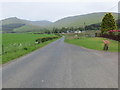
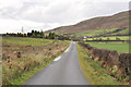
Minor road approaching Blairnairn
Looking northward from the entrance to MacLeod House.
Image: © Peter Wood
Taken: 25 May 2019
0.04 miles
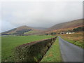
2
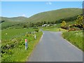
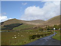
Minor road through Glen Fruin
Not far ahead is the start of the driveway leading to Macleod House; the house itself is out of shot. The buildings that can be seen in the distance are those of Blairnairn Farm; compare Image, which was taken from a point further along the same road.
Image: © Lairich Rig
Taken: 3 Jun 2011
0.05 miles
4
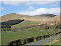
Hedge alongside minor road in Glen Fruin
Beinn Tharsuinn rises in the distance beyond the road, hedge and fields.
Image: © Trevor Littlewood
Taken: 16 Apr 2015
0.11 miles
5
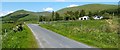
Minor road through Glen Fruin
The farm to the right of the road is Blairnairn.
The tall hill to the left is Auchengaich Hill (Image), with Beinn Tharsuinn (Image) visible further away, slightly left of centre. The background, on the right, is taken up by the slopes below Balcnock (Image).
Image: © Lairich Rig
Taken: 3 Jun 2011
0.15 miles
6
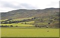
Glen Fruin
Auchengaich Hill on the left, Balcnock on the right.
Image: © Jonathan Thacker
Taken: 23 Nov 2018
0.16 miles
7
Glen Fruin road near Blairnairn
In the background is the horseshoe of hills surrounding the Allt a' Bhaile a' Mhuillin ('stream of the mill town'), with the small pointed top of Auchengaich Hill curving round to Beinn Tharsuinn ('crosswise/transverse hill').
Image: © Alan O'Dowd
Taken: 2 May 2016
0.17 miles