IMAGES TAKEN NEAR TO
Dixon Road, HELENSBURGH, G84 9DW
Introduction
This page details the photographs taken nearby to Dixon Road, G84 9DW by members of the Geograph project.
The Geograph project started in 2005 with the aim of publishing, organising and preserving representative images for every square kilometre of Great Britain, Ireland and the Isle of Man.

There are currently over 7.5m images from over14,400 individuals and you can help contribute to the project by visiting https://www.geograph.org.uk
Image Map
Images are licensed for reuse under creativecommons.org/licenses/by-sa/2.0
Notes
- Clicking on the map will re-center to the selected point.
- The higher the marker number, the further away the image location is from the centre of the postcode.
Image Listing (21 Images Found)
Images are licensed for reuse under creativecommons.org/licenses/by-sa/2.0
Image
Details
Distance
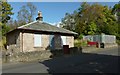
1
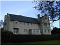
Hill House Architect: Charles Rennie Mackintosh
Hill House, the largest and finest of Mackintosh's domestic buildings, occupies a hillside that looks out over the Clyde estuary.
Image: © Michael Parry
Taken: 13 Oct 2000
0.10 miles
2
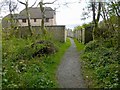
Path to Abercromby Crescent
The woodland path that is shown in Image ends here, at the northern end of Abercromby Crescent.
Image: © Lairich Rig
Taken: 19 Sep 2012
0.11 miles
3
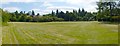
Walkers' Rest
There are two entrances to this area from Sinclair Street. The present picture was taken from near one of them (Image), and the other is at the far left.
Image: © Lairich Rig
Taken: 26 Jun 2013
0.18 miles
4
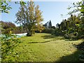
Walkers' Rest
A small park, signposted at the roadside as Walkers' Rest, is located to the east of the upper part of Sinclair Street. The present picture was taken at one of the two entrances from the street; for a view from further ahead, where the park opens out, see Image
Image: © Lairich Rig
Taken: 15 Oct 2012
0.18 miles
5
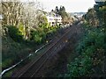
Railway line
Looking east from the bridge at Sinclair Street. The properties beside the line are on MacLachlan Road.
Image: © Richard Sutcliffe
Taken: 27 Jan 2022
0.20 miles
6
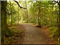
Path to Abercromby Crescent
This is one of the local council's core paths. It leads from beside the sign on Sinclair Street that is shown in Image, through an area of woodland, to Abercromby Crescent; the last part of the route is shown in Image
Image: © Lairich Rig
Taken: 19 Sep 2012
0.20 miles
7
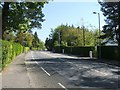
Sinclair Street, Helensburgh
This is the main road that bisects Helensburgh, and which divides many of the streets that run perpendicular to it into "East" and "West" sections.
As the map shows, the section shown here is almost at the top of the town. This part of the road is between the junctions with Image and Image
Image: © Lairich Rig
Taken: 2 May 2011
0.21 miles
8
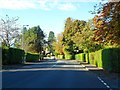
Sinclair Street, Helensburgh
From the corner of Kennedy Drive.
Image: © Stephen Sweeney
Taken: 9 Oct 2012
0.21 miles
9
Old Millig Toll House
See Image for a view of this former toll house in context.
Image: © Lairich Rig
Taken: 21 Sep 2012
0.21 miles
10
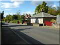
Old Millig Toll House
The prominent building on the right was formerly a toll house. It is shown here in context beside Sinclair Road at the top of Helensburgh. For a closer look at the building, see Image
Image: © Lairich Rig
Taken: 21 Sep 2012
0.21 miles