IMAGES TAKEN NEAR TO
West Dhuhill Drive, HELENSBURGH, G84 9AW
Introduction
This page details the photographs taken nearby to West Dhuhill Drive, G84 9AW by members of the Geograph project.
The Geograph project started in 2005 with the aim of publishing, organising and preserving representative images for every square kilometre of Great Britain, Ireland and the Isle of Man.

There are currently over 7.5m images from over14,400 individuals and you can help contribute to the project by visiting https://www.geograph.org.uk
Image Map
Images are licensed for reuse under creativecommons.org/licenses/by-sa/2.0
Notes
- Clicking on the map will re-center to the selected point.
- The higher the marker number, the further away the image location is from the centre of the postcode.
Image Listing (81 Images Found)
Images are licensed for reuse under creativecommons.org/licenses/by-sa/2.0
Image
Details
Distance
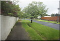
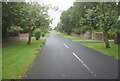
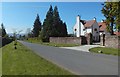
1
Kennedy Drive, Helensburgh
This picture was taken from near the junction with Image
Image: © Lairich Rig
Taken: 2 May 2011
0.09 miles
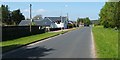
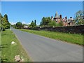
3
Blackhill Drive, Helensburgh
Blackhill Drive is one of the outlying parts of Helensburgh; as the map shows, the Glennan Burn flows just to its west.
The name Blackhill has, in modern times, been associated with the upper parts of Helensburgh, and the area just above it: see, for example, Image and Image
The item Image has further comments about the Black Hill.
In the present picture, the turning for Glen Drive is not far ahead, on the right. For a view from further ahead, near the end of this road, see Image
Image: © Lairich Rig
Taken: 1 Nov 2016
0.11 miles
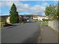
4
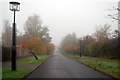
Road beside The Hill House
On a misty autumnal day. The art deco lamp-posts were designed by Charles Rennie Mackintosh.
Image: © Trevor Harris
Taken: 26 Oct 2010
0.13 miles
6
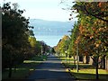
Upper Colquhoun Street, Helensburgh
Stunning view of the autumn colours, and to the River Clyde.
Image: © Stephen Sweeney
Taken: 9 Oct 2012
0.14 miles
7
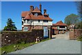
Morar House
It is now called Drumadoon, and it is seen here from Image, where it is set opposite Image The house is the work of William Leiper, who designed it for the McAlpines, proprietors of a Glasgow shipping firm; see its listing text — http://portal.historicenvironment.scot/designation/LB34763 — for further information.
Image: © Lairich Rig
Taken: 3 May 2017
0.14 miles
8
Upper Colquhoun Street, Helensburgh
The building to the right is the White House. Though overshadowed by the Hill House (Image), which is behind the photographer's position, the White House has much to commend it.
It was built for Henry S Paul, a director of Matthew Paul & Co.; he seems to have been better known locally as Harry S Paul. I believe he was the son of the Andrew Paul who is mentioned at Image, and therefore the grandson of the Matthew Paul who is described at Image
The house dates from the 1890s; the architect was Mackay Hugh Baillie Scott. A detailed description can be found in the building's listing text.
Image: © Lairich Rig
Taken: 3 May 2017
0.15 miles
9
Upper Colquhoun Street, Helensburgh
The view is from the junction with Douglas Drive.
The building to the right is Red Towers (1898; architect William Leiper; category A listed).
Image: © Lairich Rig
Taken: 30 May 2018
0.15 miles