IMAGES TAKEN NEAR TO
Main Road, HELENSBURGH, G84 8RP
Introduction
This page details the photographs taken nearby to Main Road, G84 8RP by members of the Geograph project.
The Geograph project started in 2005 with the aim of publishing, organising and preserving representative images for every square kilometre of Great Britain, Ireland and the Isle of Man.

There are currently over 7.5m images from over14,400 individuals and you can help contribute to the project by visiting https://www.geograph.org.uk
Image Map
Images are licensed for reuse under creativecommons.org/licenses/by-sa/2.0
Notes
- Clicking on the map will re-center to the selected point.
- The higher the marker number, the further away the image location is from the centre of the postcode.
Image Listing (79 Images Found)
Images are licensed for reuse under creativecommons.org/licenses/by-sa/2.0
Image
Details
Distance
1
NEW
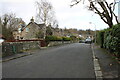
Hall Road
Residential street in Rhu.
Image: © Richard Sutcliffe
Taken: 22 Feb 2025
0.03 miles
2
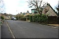
NEW
Hall Road
Residential street in Rhu. The house on the right is called Fasgadh.
Image: © Richard Sutcliffe
Taken: 22 Feb 2025
0.03 miles
3
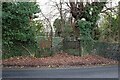
NEW
Former gateway, Gareloch Road
Ornate gates and gate piers which once gave access to the former stables, tower and greenhouse dating from 1858 (all now ruined) at Ardenvohr. The gates and gate piers are part of the Category B listing https://portal.historicenvironment.scot/apex/f?p=1505:300:::::VIEWTYPE,VIEWREF:designation,LB19503 for the buildings.
Image: © Richard Sutcliffe
Taken: 22 Feb 2025
0.04 miles
4
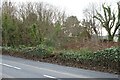
NEW
Ruins of stable block
Little remains but the overgrown walls of the Category B listed https://portal.historicenvironment.scot/apex/f?p=1505:300:::::VIEWTYPE,VIEWREF:designation,LB19503 stable block of Ardenvohr, which dates from 1858. Work was undertaken in the 1990s to convert the building to residential accommodation, but a fire in 1999 destroyed the roof and it has deteriorated since then. It is in the Buildings At Risk Register https://www.buildingsatrisk.org.uk/details/896346.
Image: © Richard Sutcliffe
Taken: 22 Feb 2025
0.06 miles
5
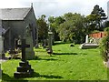
Rhu Parish Churchyard
This is the area to the north of Image The oldest memorials are not to be found here, but are in the southern part of the kirkyard.
Image: © Lairich Rig
Taken: 12 Sep 2012
0.07 miles
6
NEW
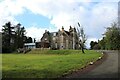
Royal Northern and Clyde Yacht Club headquarters
A Category B listed https://portal.historicenvironment.scot/apex/f?p=1505:300:::::VIEWTYPE,VIEWREF:designation,LB19507 baronial villa built by Thomas Gildard for Daniel Walkinshaw in 1857 as Ardenvohr. The Royal Northern Yacht Club was originally based in Rothesay but moved its clubhouse to Ardenvohr 1937. It merged with the Royal Clyde Yacht Club in 1978.
Image: © Richard Sutcliffe
Taken: 22 Feb 2025
0.07 miles
8
NEW
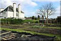
Vegetable gardens
These vegetable beds are next to Cumberland Terrace Image and are presumably tended by the occupiers.
Image: © Richard Sutcliffe
Taken: 22 Feb 2025
0.08 miles
9
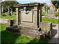
Memorial to James Guthrie (of the Glasgow Boys)
The memorial is located in the kirkyard of Image
"In Memoriam
Helen Newton Whitelaw, the beloved wife of Sir James Guthrie, P.R.S.A.,
b Apr 13 1864, d Oct 20 1912
and
Sir James Guthrie, R.S.A., LL.D., b June 10 1869, d Sept 6 1930;
Also their only child: Thomas Whitelaw Boyd Guthrie,
b Sept 30 1899, d Feb 21 1938."
James Guthrie was prominent in the influential group of artists known as the Glasgow Boys. There is a page about him at the Helensburgh Heritage website: http://www.helensburgh-heritage.co.uk/index.php?view=article&id=962
Image: © Lairich Rig
Taken: 12 Sep 2012
0.08 miles
10
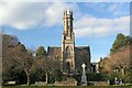
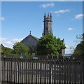
Rhu Parish Church
The Church and Tower Rhu.
Image: © John McLeish
Taken: 26 Feb 2006
0.08 miles