IMAGES TAKEN NEAR TO
Castle Avenue, HELENSBURGH, G84 8PX
Introduction
This page details the photographs taken nearby to Castle Avenue, G84 8PX by members of the Geograph project.
The Geograph project started in 2005 with the aim of publishing, organising and preserving representative images for every square kilometre of Great Britain, Ireland and the Isle of Man.

There are currently over 7.5m images from over14,400 individuals and you can help contribute to the project by visiting https://www.geograph.org.uk
Image Map
Images are licensed for reuse under creativecommons.org/licenses/by-sa/2.0
Notes
- Clicking on the map will re-center to the selected point.
- The higher the marker number, the further away the image location is from the centre of the postcode.
Image Listing (79 Images Found)
Images are licensed for reuse under creativecommons.org/licenses/by-sa/2.0
Image
Details
Distance
3
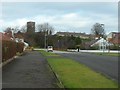
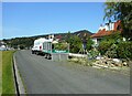
Castle Avenue, Helensburgh
Looking towards Ardencaple Tower - the last remains of the castle after which the street is named.
Image: © Stephen Sweeney
Taken: 19 Feb 2012
0.05 miles
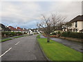
4
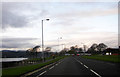
Kidston Drive
With the A814, Rhu Road Lower on the right. The Firth of Clyde is in the distance.
Image: © Richard Sutcliffe
Taken: 5 Sep 2023
0.05 miles
5
Tree removal
A local landscape gardening company have just cut down a small tree and are tidying up shrubs in a garden on Kidston Drive.
Image: © Richard Sutcliffe
Taken: 5 Sep 2023
0.05 miles
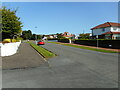
7
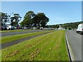
Path between the roads
The footpath here is set back from the A814, Rhu Road Lower. Kidston Drive is on the right.
Image: © Richard Sutcliffe
Taken: 5 Sep 2023
0.06 miles
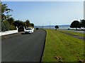
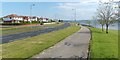
8
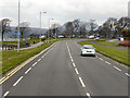
Helensburgh, Rhu Road Lower
The coastal road, near Kidston Park.
Image: © David Dixon
Taken: 19 Apr 2012
0.06 miles
9
The West Esplanade
Helensburgh's West Esplanade (Image) leads, without interruption, from beside the pier to the location shown here, beside Image
The main road visible in this photograph is Rhu Road Lower (not far to the south-east, it becomes West Clyde Street), with Kidston Avenue running parallel to it on the left. Also visible, left of centre, is the junction with Castle Avenue.
For a view in the opposite direction, see Image
Image: © Lairich Rig
Taken: 14 May 2009
0.07 miles
10
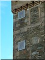
Ardencaple Tower: navigation lights
There are two fixed green lights near the top of one side of Ardencaple Tower, which is also, for the purposes of navigation, known as Ardencaple Castle Light. The tower itself is the sole standing remnant of Ardencaple Castle.
For context, see Image, a view of the whole tower; the lights can be seen in that picture. For related pictures, click on the end-note title.
Image: © Lairich Rig
Taken: 17 Nov 2014
0.08 miles