IMAGES TAKEN NEAR TO
Rhu, HELENSBURGH, G84 8LS
Introduction
This page details the photographs taken nearby to G84 8LS by members of the Geograph project.
The Geograph project started in 2005 with the aim of publishing, organising and preserving representative images for every square kilometre of Great Britain, Ireland and the Isle of Man.

There are currently over 7.5m images from over14,400 individuals and you can help contribute to the project by visiting https://www.geograph.org.uk
Image Map
Images are licensed for reuse under creativecommons.org/licenses/by-sa/2.0
Notes
- Clicking on the map will re-center to the selected point.
- The higher the marker number, the further away the image location is from the centre of the postcode.
Image Listing (13 Images Found)
Images are licensed for reuse under creativecommons.org/licenses/by-sa/2.0
Image
Details
Distance
1

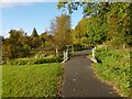
Playing field in Rhu
The playing fields are located at the northern end of Image; to their right is a footpath / cycle path. The same playing fields and path appear in Image, which is a view in the opposite direction.
Image: © Lairich Rig
Taken: 15 Oct 2012
0.11 miles
2
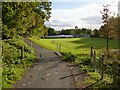
Regional Route 42
This is a view over the same section of the cycle path as shown in Image, the railings indicating where the path crosses a small burn.
Image: © Lairich Rig
Taken: 15 Oct 2012
0.11 miles
3
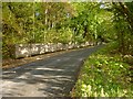
Regional Route 42
The picture was taken from about 90 metres further along the cycle path that is shown in Image For another view of the area in the background, see Image
For a view in the opposite direction, see Image
Image: © Lairich Rig
Taken: 15 Oct 2012
0.11 miles
4
Smuggler's Way, Rhu
The road is called Aros Road up to this point, but from about here onwards it is called Smuggler's Way.
A cycle path branches off from the road here: Image
The road crosses the course of the Aldownick Burn. On the name Smuggler's Way, see the comments on Image, a location further up the glen of that burn.
Image: © Lairich Rig
Taken: 15 Oct 2012
0.15 miles
5
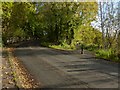
Regional Route 42
At the time of writing, this cycle path is not yet shown on the OS map. The beginning of this section of it is shown in Image For a view from further ahead, see Image
Image: © Lairich Rig
Taken: 15 Oct 2012
0.16 miles
6
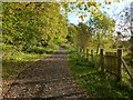
Cycle path leaving Smuggler's Way
Aros Road becomes Image at about the point where the cycle path, part of Regional Route 42, branches off to the right. See Image for a view of the near section of the cycle path.
Image: © Lairich Rig
Taken: 15 Oct 2012
0.17 miles
7

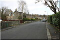
Cumberland Road, Rhu
The junction with School Road is not far ahead, on the right.
Image: © Lairich Rig
Taken: 15 Oct 2012
0.18 miles
8
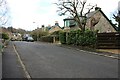
Hall Road
Residential street in Rhu. The house on the right is called Fasgadh.
Image: © Richard Sutcliffe
Taken: 22 Feb 2025
0.18 miles
9
Hall Road
Residential street in Rhu.
Image: © Richard Sutcliffe
Taken: 22 Feb 2025
0.19 miles
10
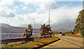
Along the east side of Gare Loch at Rhu, 1994
View NW on A814 towards Faslane and Garelochhead - where 'Trident' lurks.
Image: © Ben Brooksbank
Taken: 22 Jun 1994
0.21 miles