IMAGES TAKEN NEAR TO
Rhu, HELENSBURGH, G84 8LP
Introduction
This page details the photographs taken nearby to G84 8LP by members of the Geograph project.
The Geograph project started in 2005 with the aim of publishing, organising and preserving representative images for every square kilometre of Great Britain, Ireland and the Isle of Man.

There are currently over 7.5m images from over14,400 individuals and you can help contribute to the project by visiting https://www.geograph.org.uk
Image Map
Images are licensed for reuse under creativecommons.org/licenses/by-sa/2.0
Notes
- Clicking on the map will re-center to the selected point.
- The higher the marker number, the further away the image location is from the centre of the postcode.
Image Listing (17 Images Found)
Images are licensed for reuse under creativecommons.org/licenses/by-sa/2.0
Image
Details
Distance
1
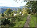
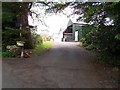
Footpath to Rhu from Highlandman's Wood
This photo was taken only 200 metres or so from the point where a footpath called Highlandman's Road leaves the woods. From there, the path continues downhill, passing the house shown here (which stands on the northern side of the path), and then Torr Farm (which lies on the other side).
The Gare Loch cannot be seen in this photograph (except for a tiny strip at the far left of the picture), but the Rosneath Peninsula lies beyond it, visible as the nearer range of hills in the background; yet further, lying beyond another unseen stretch of water, are the hills of the Cowal Peninsula, which can be seen here on the distant skyline.
Image: © Lairich Rig
Taken: 5 Oct 2008
0.02 miles
2
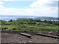
Rhu - Helensburgh, Hill House Track, View
Looking over Tor Farm land and Roseneath Point to Gourock
Image: © william craig
Taken: 2 Jun 2006
0.06 miles
3
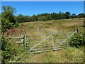
Field gate
The picture was taken from the road, which is here part of an old route called the Highlandman's Road.
Image: © Lairich Rig
Taken: 9 Jul 2014
0.07 miles
4
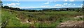
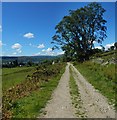
View from the Highlandman's Road
This is a wide-angle view from the Image The Rosneath Peninsula juts in from the right, with the entrance to the Gareloch on its near side, and the Firth of Clyde behind. In the leftmost visible part of the Firth is Ardmore Point, easier to see with larger image sizes.
Image: © Lairich Rig
Taken: 9 Jul 2014
0.08 miles
5
Rhu - Helensburgh, Hill House Track, Tor Farm
Image: © william craig
Taken: 2 Jun 2006
0.09 miles
6
Highlandman's Road
This is the section between Highlandman's Wood and Rhu.
Image: © Lairich Rig
Taken: 9 Jul 2014
0.10 miles
7
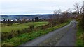
Approaching Rhu on Highlandman's Road
On the far side of the Gairloch, the sheds of Silvers Marine can just be made out.
Image: © Gordon Brown
Taken: 16 Nov 2019
0.11 miles
8
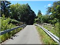
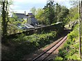
Bridge over West Highland Line at Torr
The railings and barriers are recent; compare another contributor's earlier picture: Image
Image: © Lairich Rig
Taken: 9 Jul 2014
0.14 miles
9
West Highland Line at Rhu
This view was taken from a bridge ( http://www.geograph.org.uk/photo/178851 ); for a view from the same bridge, but looking in the opposite direction, see http://www.geograph.org.uk/photo/178847
Image: © Lairich Rig
Taken: 14 May 2009
0.16 miles
10
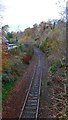
Single track line to Oban and Fort William
Image: © Gordon Brown
Taken: 16 Nov 2019
0.17 miles