IMAGES TAKEN NEAR TO
Rhu Road Higher, HELENSBURGH, G84 8JZ
Introduction
This page details the photographs taken nearby to Rhu Road Higher, G84 8JZ by members of the Geograph project.
The Geograph project started in 2005 with the aim of publishing, organising and preserving representative images for every square kilometre of Great Britain, Ireland and the Isle of Man.

There are currently over 7.5m images from over14,400 individuals and you can help contribute to the project by visiting https://www.geograph.org.uk
Image Map
Images are licensed for reuse under creativecommons.org/licenses/by-sa/2.0
Notes
- Clicking on the map will re-center to the selected point.
- The higher the marker number, the further away the image location is from the centre of the postcode.
Image Listing (34 Images Found)
Images are licensed for reuse under creativecommons.org/licenses/by-sa/2.0
Image
Details
Distance
1
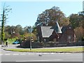
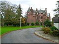
West Lodge of Dalmore House
Like several other buildings in this area (compare Image), Image and its two lodges are the work of William Leiper ( http://www.geograph.org.uk/snippet/5615 ); at the time of writing, all three buildings are still in existence.
Image: © Lairich Rig
Taken: 3 Jun 2011
0.06 miles
2
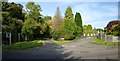
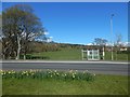
The start of Glenoran Road
Just left of centre, Glenoran Road branches off from Rhu Road Higher (which runs from left to right in the foreground). Not far ahead, in the shade of the trees, Mill Lane in turn branches off from Glenoran Road.
Glenoran Road used to lead to a garden centre (which was latterly a Dobbies); the centre closed in 2005, and the land was sold in 2007.
Image: © Lairich Rig
Taken: 28 Sep 2013
0.07 miles
3
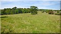
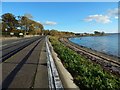
Field beside Gareloch Road
This open space is on the north-eastern side of the road, almost opposite the point shown in Image The outskirts of Helensburgh are on the right, and those of Rhu on the left. Tor Wood is in the left background.
For a view from further back, on the other side of the road, see Image
Image: © Lairich Rig
Taken: 28 Sep 2013
0.08 miles
5
Dalmore House
The building dates from 1873. Two lodges were associated with it; one of them is shown in Image
Image: © Lairich Rig
Taken: 26 Oct 2011
0.09 miles
6
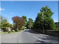
View across Gareloch Road
The picture was taken from a point not far from Image, which is a little to the north-west along the road. For the field on the other side of the road, see Image
Image: © Lairich Rig
Taken: 21 Apr 2016
0.10 miles
7
Gareloch Road at Ardencaple
The road passes Image here (compare Image, a view in the opposite direction).
Cairndhu Point is in the right background.
Image: © Lairich Rig
Taken: 1 Nov 2016
0.13 miles
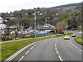
8
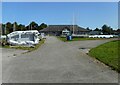
Helensburgh Sailing Club
Seen from their slipway.
Image: © Richard Sutcliffe
Taken: 5 Sep 2023
0.13 miles
9
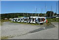
Stored inflatables
Inflatable boats stacked on their sides near the shore at the Helensburgh Sailing Club.
Image: © Richard Sutcliffe
Taken: 5 Sep 2023
0.15 miles
10
Helensburgh Sailing Club, Gareloch Road
Image: © David Dixon
Taken: 19 Apr 2012
0.15 miles