IMAGES TAKEN NEAR TO
Rhu, HELENSBURGH, G84 8JY
Introduction
This page details the photographs taken nearby to G84 8JY by members of the Geograph project.
The Geograph project started in 2005 with the aim of publishing, organising and preserving representative images for every square kilometre of Great Britain, Ireland and the Isle of Man.

There are currently over 7.5m images from over14,400 individuals and you can help contribute to the project by visiting https://www.geograph.org.uk
Image Map
Images are licensed for reuse under creativecommons.org/licenses/by-sa/2.0
Notes
- Clicking on the map will re-center to the selected point.
- The higher the marker number, the further away the image location is from the centre of the postcode.
Image Listing (7 Images Found)
Images are licensed for reuse under creativecommons.org/licenses/by-sa/2.0
Image
Details
Distance
1
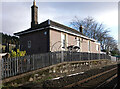
Ardencaple Crossing House
Ardencaple Level Crossing Keepers House near Rhu
This was not a railway station, but the apparent rail platform in front of the keepers house, indicates that it could have been used as an 'on-request' “Halt”.
A local story is that the halt was used by Prime Minister Andrew Bonar Law when he was Prime Minister, to travel to nearby Glenoran House.
The story is probably untrue because during his short tenure as Prime Minister in 1922/3, Bonar Law’s home was “Seabank” at 40 East Clyde St, Helensburgh.
However, it is not unlikely that Bonar Law’s super-rich relative Charles Kidson, who owned Glenoran, would have had the ‘clout’ to treat the level crossing as a personal train stop, if he had so wished.
Ardencaple Farm, for which the level crossing was intended, now has its own access road.
Image: © Pete Marrison
Taken: 30 Jan 2023
0.16 miles
2
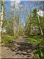
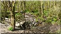
Footpath in Duchess Wood
This is the western extremity of the network of paths in Duchess Wood. Different parts of the same path are shown in Image and on the right in Image
Image: © Lairich Rig
Taken: 15 May 2013
0.16 miles
3
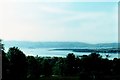
Helensburgh - 1973
Helensburgh, Gare Loch, Rosneath Point seen from the West Highland Line.
Image: © Helmut Zozmann
Taken: 20 Jul 1973
0.19 miles
4
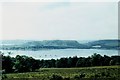
Helensburgh - 1973
Helensburgh, Gare Loch, Rosneath Point seen from the West Highland Line.
Image: © Helmut Zozmann
Taken: 20 Jul 1973
0.19 miles
5
Footpath in Duchess Wood
The footbridge is located on the path that is shown on the right in Image, at the point where that path re-enters the woods.
Image: © Lairich Rig
Taken: 15 May 2013
0.21 miles
6
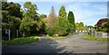
The start of Glenoran Road
Just left of centre, Glenoran Road branches off from Rhu Road Higher (which runs from left to right in the foreground). Not far ahead, in the shade of the trees, Mill Lane in turn branches off from Glenoran Road.
Glenoran Road used to lead to a garden centre (which was latterly a Dobbies); the centre closed in 2005, and the land was sold in 2007.
Image: © Lairich Rig
Taken: 28 Sep 2013
0.23 miles
7
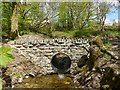
Footbridge in Duchess Wood
The footbridge is on a Image The present view illustrates that the line of the West Highland Railway is nearby, at the edge of the woods.
Image: © Lairich Rig
Taken: 15 May 2013
0.25 miles