IMAGES TAKEN NEAR TO
Ferniegair Avenue, HELENSBURGH, G84 8HB
Introduction
This page details the photographs taken nearby to Ferniegair Avenue, G84 8HB by members of the Geograph project.
The Geograph project started in 2005 with the aim of publishing, organising and preserving representative images for every square kilometre of Great Britain, Ireland and the Isle of Man.

There are currently over 7.5m images from over14,400 individuals and you can help contribute to the project by visiting https://www.geograph.org.uk
Image Map
Images are licensed for reuse under creativecommons.org/licenses/by-sa/2.0
Notes
- Clicking on the map will re-center to the selected point.
- The higher the marker number, the further away the image location is from the centre of the postcode.
Image Listing (40 Images Found)
Images are licensed for reuse under creativecommons.org/licenses/by-sa/2.0
Image
Details
Distance
1
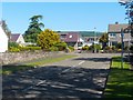
Camsail Avenue, Helensburgh
The photograph was taken from the junction with West Clyde Street / Rhu Road Lower (the street name changes at about that point). The short Camsail Avenue leads away from the photographer's position, and towards Ferniegair Avenue, which appears in the background.
Image: © Lairich Rig
Taken: 3 Jun 2011
0.03 miles
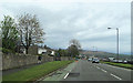
4
Rhu Road Lower
The photograph was taken from the junction with Image West Clyde Street becomes Rhu Road Lower at about that point. In the background, the Rosneath Peninsula can be seen on the other side of the Gare Loch.
For other views, see Image and Image
Image: © Lairich Rig
Taken: 3 Jun 2011
0.07 miles
5
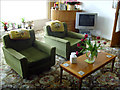
Bungalow interior
A totally uncontrived museum piece. Part of the lounge in one of the large bungalows along the sea-front road in Helensburgh.
Image: © Howard Selina
Taken: Unknown
0.08 miles
7
Restricted access
I don't know what access is restricted on this part of West Princes Street - it's not at all obvious.
Image: © Richard Sutcliffe
Taken: 27 Jan 2022
0.10 miles
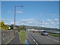
8
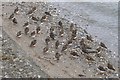
Turnstones at Helensburgh
This flock of thirty-eight turnstones was on a narrow strip of exposed beach between the Clyde and the sea wall that runs alongside Image For more information on these little birds, see Image
Image: © Lairich Rig
Taken: 2 Apr 2013
0.10 miles
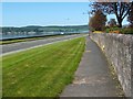
9
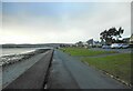
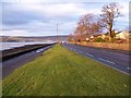
The promenade, Helensburgh
Looking west.
Image: © Richard Sutcliffe
Taken: 27 Jan 2022
0.10 miles
10
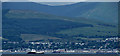
Helensburgh from Greenock
The sunken sugar ship Captayannis http://en.wikipedia.org/wiki/MV_Captayannis can be seen in the left foreground, with the paddle steamer Waverley to her right, having just left Helensburgh Pier. Viewed from Cartsburn.
Image: © Thomas Nugent
Taken: 13 Jul 2013
0.10 miles