IMAGES TAKEN NEAR TO
Collins Road, HELENSBURGH, G84 7UB
Introduction
This page details the photographs taken nearby to Collins Road, G84 7UB by members of the Geograph project.
The Geograph project started in 2005 with the aim of publishing, organising and preserving representative images for every square kilometre of Great Britain, Ireland and the Isle of Man.

There are currently over 7.5m images from over14,400 individuals and you can help contribute to the project by visiting https://www.geograph.org.uk
Image Map
Images are licensed for reuse under creativecommons.org/licenses/by-sa/2.0
Notes
- Clicking on the map will re-center to the selected point.
- The higher the marker number, the further away the image location is from the centre of the postcode.
Image Listing (34 Images Found)
Images are licensed for reuse under creativecommons.org/licenses/by-sa/2.0
Image
Details
Distance
2
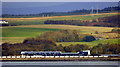
Hermitage Academy, Craigendoran
Viewed from Customhouse Quay, Greenock. A tanker train is stopped in front of the school, waiting to come off the West Highland Line onto the North Clyde Line. The junction is just out of sight to the right.
Image: © Thomas Nugent
Taken: 30 Oct 2017
0.10 miles
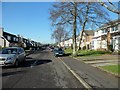
3
Collins Road, Craigendoran
Collins Road, receding into the distance, is named after Michael Collins, one of the crew members of Apollo 11; the other two astronauts on that mission are commemorated by the names of Armstrong Road and Aldrin Road, which are just to the north. For another view, see Image
Other nearby streets are named according to a different theme: see Image
Drumfork Road is in the foreground, heading off to the right.
Image: © Lairich Rig
Taken: 3 May 2012
0.10 miles
4

Collins Road
View of Craigendoran's Collins Road from the woodland that once flanked the policies of Camis Eskan.
Image: © Richard Webb
Taken: 26 Apr 2022
0.14 miles
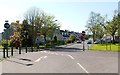
5
Kenilworth Avenue, Craigendoran
The name of the street is drawn from one of Sir Walter Scott's novels. Other nearby streets whose names are related to his works include Waverley Avenue, Guy Mannering Road, Talisman Crescent, Redgauntlet Road, Marmion Avenue, Ashton Drive (from "The Bride of Lammermoor"), and Image (from "The Heart of Midlothian"). There is also an Abbotsford Drive (compare Image).
Another area nearby has astronaut-themed street names: see Image Another street name of interest is found near Craigendoran Station: Image is presumably named after the Dennistouns of Colgrain (their surname was anciently spelled Danzielstoun).
The present photograph was taken from the junction with Campbell Drive (probably a reference to the Campbells of Colgrain, Image, who purchased the lands of Colgrain from the above-mentioned Dennistouns in 1836; see, for example, Image).
Image: © Lairich Rig
Taken: 3 May 2012
0.14 miles
6
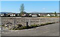
The former site of Hermitage Academy
The old building, shown in Image, has been cleared away. See Image and Image for the new building, which is not far from here.
Image: © Lairich Rig
Taken: 3 May 2012
0.15 miles
7
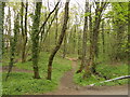
Woodland, Craigendoran Burn
A long woodland beside the burn with several paths.
Image: © Richard Webb
Taken: 26 Apr 2022
0.15 miles
8

The Craigendoran Burn
The subject is as in Image, but the present view is downstream rather than upstream. The adjacent road (see the map) is at the top of the bank to the left.
Image: © Lairich Rig
Taken: 6 Jun 2014
0.15 miles
9
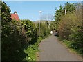
Path to Drumfork Road
The path leaves the main road near Image, and meets up with Drumfork Road at the point shown in the foreground, on the left, in Image
Image: © Lairich Rig
Taken: 3 May 2012
0.15 miles
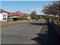
10
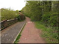
Drumfork Road
A decommissioned road, now a path but still with speed bumps and half obscured road markings.
Image: © Richard Webb
Taken: 26 Apr 2022
0.15 miles