IMAGES TAKEN NEAR TO
East Argyle Street, HELENSBURGH, G84 7RS
Introduction
This page details the photographs taken nearby to East Argyle Street, G84 7RS by members of the Geograph project.
The Geograph project started in 2005 with the aim of publishing, organising and preserving representative images for every square kilometre of Great Britain, Ireland and the Isle of Man.

There are currently over 7.5m images from over14,400 individuals and you can help contribute to the project by visiting https://www.geograph.org.uk
Image Map
Images are licensed for reuse under creativecommons.org/licenses/by-sa/2.0
Notes
- Clicking on the map will re-center to the selected point.
- The higher the marker number, the further away the image location is from the centre of the postcode.
Image Listing (276 Images Found)
Images are licensed for reuse under creativecommons.org/licenses/by-sa/2.0
Image
Details
Distance
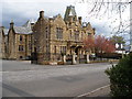
2
Malig Mill
Some work has been carried here, part of a larger program of improvements to the park. See also Image, visible just ahead. See Image for a view in the opposite direction from there.
Image: © Lairich Rig
Taken: 6 Aug 2018
0.04 miles
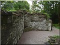
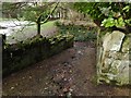
3
Remains of Malig Mill
These are the ruins of a mill, located on the western side of Image (see also Image) where it flows through Image The mill is close to the Image, and it only became derelict early in the twentieth century.
There was a mill here in the eighteenth century, if not earlier: Image See Image for a memorial of someone who worked there.
Helensburgh Heritage Trust have made detailed information about the mill available as a PDF download from their site: http://www.helensburgh-heritage.co.uk/pdfs/MaligMill.pdf ("Malig Mill: a Brief History" by Jim Chestnut). The same site has an article on the mill by Donald Fullarton: http://www.helensburgh-heritage.co.uk/index.php?view=article&id=544
Blaeu's 1654 map of the Lennox shows a mill here: "Mulligs m." (the map is quite consistent in its use of abbreviations: "B." for burn, "K." for Kirk, "M." for mill, etc.). There was therefore a mill in the area at that time, but it was not necessarily at the spot shown in the present photograph. Blaeu's map was largely based on Timothy Pont's surveying work carried out in the 1580s-90s, so it is likely that there was a mill in the area at this earlier period.
- - • - -
Rather than repeat information provided at the links given above, I will list some earlier appearances of the old name (Millig/Mulig, etc.) of this area; it can be traced back at least as far as the early thirteenth century (the following discussion is intended primarily for those with a keen interest in place-names).
The old name is commemorated by Helensburgh's present-day Millig Street. James Colquhoun founded the town in 1777, naming it after his wife Helen. See Image for references explaining how James came to acquire the land on which he founded his new town [see also pages 112, 116 and 118 of "The Annals of Garelochside" (1897) by W.C.Maughan].
A retour (dated 1680) by Charles II names "Milligis" along with other nearby places whose names are still recognisable: "Camseskaines" (Camis Eskan – Image), "Cowgraine" (Colgrain – Image), and so on.
Charter no. 1901 in the second volume of the Register of the Great Seal (RMS) of Scotland dates from the 16th of October, 1489, and is by King James IV. It mentions the "terras de Mulig, Bannachar", "the lands of Mulig and Bannachar" (the latter place is nearby Bannachra – Image).
[Also, to give just a few examples, "Myllegis" in RMS Vol 4, charter #156 (AD 1547), and the similar "Millegis", in both charter #1623 (AD 1565) in the same volume and charter #3140 (AD 1545) in volume 3.]
A charter (dated 1351) by Donald, Earl of Lennox, makes mention of the
lands "de Fosselane, et de Glenfrone, et de Muleig". The first two places listed here are present-day Faslane (c.Image) and Glen Fruin (c.Image).
Finally, a charter of confirmation (from 1225) by Alexander King of Scots (Alexander II, who reigned from 1214-1249) was made "apud Cadihow, ultimo de Maii, anno regni nostri duodecimo": "at Cadzow, on the last day of May, in the 12th year of our reign". Cadzow (earlier written "Cadȝow") was near present-day Hamilton – c.Image The charter mentions the lands "de Neved, Glanfrone, Moigliag", and so on (the index uses the spelling "Moiliag", which is closer to the later forms of the name). "Glanfrone" is Glen Fruin. The place-name "Neved" is evidently related to the present-day name Rosneath ("headland of Neath" – c.Image); however, Neved/Neath denoted a considerably larger area [see Simon Taylor's comments on page 18 of "Changing Identities, Ancient Roots" (2007)].
References for the charters:
(1) Retour from 1680 by Charles II:
Lennox Cartulary ["Cartularium Comitatus de Levenax", Maitland Club Edition (1833)] –
Addenda, "10. Retornatus terrarum et comitatus de Levenax, 1680" (pages 100-102).
(2) Charter from 1489 by James IV:
"Register of the Great Seal of Scotland" (RMS), Volume 2, page 399, no. 1901.
(3) Charter from 1351 by Donald, Earl of Lennox:
Lennox Cartulary – Addenda, "4. Carta quarundem terrarum et officiorum predicto Waltero, 1351", pages 93-94.
(4) Charter from 1225 by Alexander II King of Scots:
Lennox Cartulary – Addenda, "2. Confirmatio de Neved et aliis terris Hamelen filio comitis Alwini, 1225", pages 91-92.
Image: © Lairich Rig
Taken: 3 May 2012
0.04 miles
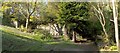
4
Malig Mill: detail
See Image for the main description. The present picture shows the entrance that appears on the right, in dense shade, in that view.
For a view from the opening that is just ahead, see Image
Click on the end-note title for related pictures.
Image: © Lairich Rig
Taken: 2 Feb 2015
0.04 miles
5
Malig Mill: detail
As a comparison of the two pictures makes clear, the present view is from just beyond the ruined doorway shown in Image
See Image for the main description of these ruins. Click on the end-note title for related pictures.
Image: © Lairich Rig
Taken: 2 Feb 2015
0.04 miles
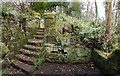
6
Malig Mill: detail
This is a view back from the top of the flight of steps that is shown in Image
See Image for the main description of the ruin, and click on the end-note title for related pictures.
Image: © Lairich Rig
Taken: 2 Feb 2015
0.04 miles
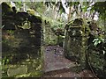
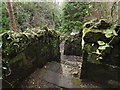
7
Malig Mill: detail
This is a view of the western side of the ruins, looking out from the interior, in roughly the direction of the nearby Image Compare Image, a view in the opposite direction from the far end of the projecting section of wall.
See Image for the main description of the ruin, and click on the relevant end-note title for related pictures.
Image: © Lairich Rig
Taken: 2 Feb 2015
0.04 miles
8
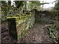
Malig Mill: detail
This shows the western side of the ruin; compare Image, a view in the opposite direction. The same projecting section of wall is prominent in that picture.
See Image for the main description of the ruin, and click on the relevant end-note title for related pictures.
Image: © Lairich Rig
Taken: 2 Feb 2015
0.04 miles
9

Victoria Halls
The building is located alongside Sinclair Street. For other views, and for more information, see Image / Image / Image / Image
A large tapestry inside records, amongst other things, modifications to the building in 1899.
According to a small plaque nearby, the trees at the front, that is, between the building and Sinclair Street, were planted by Helensburgh schoolchildren on 21 June 1985 to commemorate the 40th anniversary of the atomic bombing of Hiroshima and Nagasaki.
Image: © Lairich Rig
Taken: 28 Sep 2013
0.04 miles
10
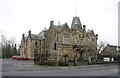
Victoria Halls
Category B listed [http://portal.historicenvironment.scot/designation/LB34869] halls on Sinclair Street, dating from 1887.
Image: © Richard Sutcliffe
Taken: 1 Mar 2019
0.04 miles