IMAGES TAKEN NEAR TO
Cardross Road, HELENSBURGH, G84 7JW
Introduction
This page details the photographs taken nearby to Cardross Road, G84 7JW by members of the Geograph project.
The Geograph project started in 2005 with the aim of publishing, organising and preserving representative images for every square kilometre of Great Britain, Ireland and the Isle of Man.

There are currently over 7.5m images from over14,400 individuals and you can help contribute to the project by visiting https://www.geograph.org.uk
Image Map
Images are licensed for reuse under creativecommons.org/licenses/by-sa/2.0
Notes
- Clicking on the map will re-center to the selected point.
- The higher the marker number, the further away the image location is from the centre of the postcode.
Image Listing (67 Images Found)
Images are licensed for reuse under creativecommons.org/licenses/by-sa/2.0
Image
Details
Distance
1
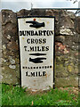
Old milepost
This milepost is on an old section of Cardross Road in Craigendoran, where the A814 has been straightened slightly. One of 4 remaining on the 8 mile stretch of road between Dumbarton and Helensburgh probably set up in the late 19C.
Image: © Hilary Jones
Taken: 11 Aug 2023
0.02 miles
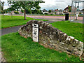
2

Old milestone in Craigendoran
←
DUNBARTON
CROSS
7 MILES
→
HELENSBURGH
1 MILE
The milestone stands beside Cardross Road, the main road through Craigendoran: Image A mile to the south-east is another milestone built to the same pattern (Image), and there is another Image All of these stones were set up before 1860.
They feature the spelling Dunbarton (rather than Dumbarton) because the Commissioners of Supply, and the Trustees for the Turnpike Roads, who had oversight of such matters, were drawn from the country gentry, who appear to have been attracted to the mock antiquity of the spelling (although they were not entirely consistent: Image).
[Much earlier, the minister James Oliphant (Image) had given the "Dun-" variant an air of respectability by employing it (for both the burgh and the county) in the Old Statistical Account (1792).]
However, it was only considerably later (in the 1930s) that a County Clerk persuaded the OS to use the "Dun-" spelling for the county name [see pages 47 and 92-94 of I M M MacPhail's "Lennox Lore" (1987)].
Not far away, an old Image is, despite appearances, essentially the same. The metal part has simply been set in front of a wall rather than in front of a stone structure built specially for it.
Image: © Lairich Rig
Taken: 13 Apr 2012
0.03 miles
3
Old milepost
This shows the milepost in Craigendorran that is on the old piece of road with a view of the straightened A814 and bus-stop. Another milepost on its own little wall.
Image: © Hilary Jones
Taken: 11 Aug 2023
0.03 miles
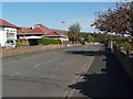
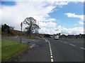
4

Cardross Road, Craigendoran
The busy main road through Craigendoran runs parallel to this one, and can be seen on the left with yellow signs alongside it. An Image can be seen in this area.
Image: © Lairich Rig
Taken: 13 Apr 2012
0.03 miles
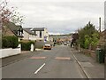
5
Kenilworth Avenue, Craigendoran
The name of the street is drawn from one of Sir Walter Scott's novels. Other nearby streets whose names are related to his works include Waverley Avenue, Guy Mannering Road, Talisman Crescent, Redgauntlet Road, Marmion Avenue, Ashton Drive (from "The Bride of Lammermoor"), and Image (from "The Heart of Midlothian"). There is also an Abbotsford Drive (compare Image).
Another area nearby has astronaut-themed street names: see Image Another street name of interest is found near Craigendoran Station: Image is presumably named after the Dennistouns of Colgrain (their surname was anciently spelled Danzielstoun).
The present photograph was taken from the junction with Campbell Drive (probably a reference to the Campbells of Colgrain, Image, who purchased the lands of Colgrain from the above-mentioned Dennistouns in 1836; see, for example, Image).
Image: © Lairich Rig
Taken: 3 May 2012
0.03 miles
7
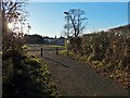
Path to Cardross Road
At the time of writing, the map shows this as a road, but it is simply a path that meets the main road near Image
Image: © Lairich Rig
Taken: 23 Nov 2016
0.06 miles
10
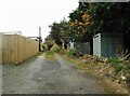
Back lane
The lane runs between Moore Drive and Dennistoun Crescent, giving access to the rear of the properties on both streets. It continues under the railway and joins a track beside the shore.
Image: © Richard Sutcliffe
Taken: 11 Nov 2022
0.09 miles