IMAGES TAKEN NEAR TO
Lawrence Avenue, HELENSBURGH, G84 7JJ
Introduction
This page details the photographs taken nearby to Lawrence Avenue, G84 7JJ by members of the Geograph project.
The Geograph project started in 2005 with the aim of publishing, organising and preserving representative images for every square kilometre of Great Britain, Ireland and the Isle of Man.

There are currently over 7.5m images from over14,400 individuals and you can help contribute to the project by visiting https://www.geograph.org.uk
Image Map
Images are licensed for reuse under creativecommons.org/licenses/by-sa/2.0
Notes
- Clicking on the map will re-center to the selected point.
- The higher the marker number, the further away the image location is from the centre of the postcode.
Image Listing (67 Images Found)
Images are licensed for reuse under creativecommons.org/licenses/by-sa/2.0
Image
Details
Distance
1
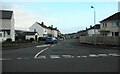
Lawrence Avenue
Residential street.
Image: © Richard Sutcliffe
Taken: 11 Nov 2022
0.06 miles
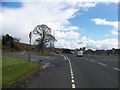
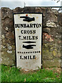
3
Old milepost
This shows the milepost in Craigendorran that is on the old piece of road with a view of the straightened A814 and bus-stop. Another milepost on its own little wall.
Image: © Hilary Jones
Taken: 11 Aug 2023
0.08 miles
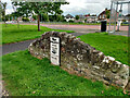
4

Old milestone in Craigendoran
←
DUNBARTON
CROSS
7 MILES
→
HELENSBURGH
1 MILE
The milestone stands beside Cardross Road, the main road through Craigendoran: Image A mile to the south-east is another milestone built to the same pattern (Image), and there is another Image All of these stones were set up before 1860.
They feature the spelling Dunbarton (rather than Dumbarton) because the Commissioners of Supply, and the Trustees for the Turnpike Roads, who had oversight of such matters, were drawn from the country gentry, who appear to have been attracted to the mock antiquity of the spelling (although they were not entirely consistent: Image).
[Much earlier, the minister James Oliphant (Image) had given the "Dun-" variant an air of respectability by employing it (for both the burgh and the county) in the Old Statistical Account (1792).]
However, it was only considerably later (in the 1930s) that a County Clerk persuaded the OS to use the "Dun-" spelling for the county name [see pages 47 and 92-94 of I M M MacPhail's "Lennox Lore" (1987)].
Not far away, an old Image is, despite appearances, essentially the same. The metal part has simply been set in front of a wall rather than in front of a stone structure built specially for it.
Image: © Lairich Rig
Taken: 13 Apr 2012
0.08 miles
5
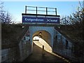
Subway entrance to Craigendoran station, 1994
View SW under the line to Helensburgh Upper, Arrochar and Fort William and then the branch to Helensburgh Central: ex-North British Glasgow Queen Street - Fort William 'West Highland' line, Helensburgh Central being the western terminus of the electrified North Clyde Lines of Strathclyde Transport, to The left being Dumbarton, Clydebank and Glasgow, then Shettleston, Coatbridge and Airdrie.
Image: © Ben Brooksbank
Taken: 22 Jun 1994
0.08 miles
6

Cardross Road, Craigendoran
The busy main road through Craigendoran runs parallel to this one, and can be seen on the left with yellow signs alongside it. An Image can be seen in this area.
Image: © Lairich Rig
Taken: 13 Apr 2012
0.08 miles
7
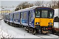
Abandoned Train at Craigendoran Railway Station
A ScotRail train lies abandoned at Craigendoran Railway Station during heavy snow. The train was conducting a proving run between Yoker depot and Helensburgh Central and became stuck in a snowdrift at the station
The train was left overnight and was picked up the next day and taken back to Yoker depot. As seen the pantograph is down, and there is snow seen on the roof of the train.
Image: © Adam Forsyth
Taken: 3 Mar 2018
0.08 miles
8
Old milepost
This milepost is on an old section of Cardross Road in Craigendoran, where the A814 has been straightened slightly. One of 4 remaining on the 8 mile stretch of road between Dumbarton and Helensburgh probably set up in the late 19C.
Image: © Hilary Jones
Taken: 11 Aug 2023
0.08 miles
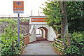
9
Entrance to Craigendoran Station
The subject is as in Image, but the picture was taken 22 years later. For the platform, see Image This path to the station begins on Image
Image: © Lairich Rig
Taken: 23 Nov 2016
0.09 miles
10
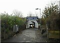
Entrance to Craigendoran Station
A path from Dennistoun Crescent leads via a subway under the West Highland line to the station platform. Trains run from here west to Helensburgh Central and east to Dumbarton, Glasgow and Edinburgh.
Image: © Richard Sutcliffe
Taken: 11 Nov 2022
0.09 miles