IMAGES TAKEN NEAR TO
Lawrence Avenue, HELENSBURGH, G84 7JH
Introduction
This page details the photographs taken nearby to Lawrence Avenue, G84 7JH by members of the Geograph project.
The Geograph project started in 2005 with the aim of publishing, organising and preserving representative images for every square kilometre of Great Britain, Ireland and the Isle of Man.

There are currently over 7.5m images from over14,400 individuals and you can help contribute to the project by visiting https://www.geograph.org.uk
Image Map
Images are licensed for reuse under creativecommons.org/licenses/by-sa/2.0
Notes
- Clicking on the map will re-center to the selected point.
- The higher the marker number, the further away the image location is from the centre of the postcode.
Image Listing (69 Images Found)
Images are licensed for reuse under creativecommons.org/licenses/by-sa/2.0
Image
Details
Distance
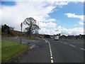
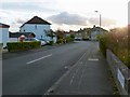
2
Lawrence Avenue
Residential street.
Image: © Richard Sutcliffe
Taken: 11 Nov 2022
0.05 miles
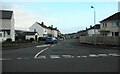
3

Cardross Road, Craigendoran
The busy main road through Craigendoran runs parallel to this one, and can be seen on the left with yellow signs alongside it. An Image can be seen in this area.
Image: © Lairich Rig
Taken: 13 Apr 2012
0.06 miles
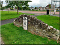
4

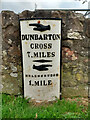
Old milestone in Craigendoran
←
DUNBARTON
CROSS
7 MILES
→
HELENSBURGH
1 MILE
The milestone stands beside Cardross Road, the main road through Craigendoran: Image A mile to the south-east is another milestone built to the same pattern (Image), and there is another Image All of these stones were set up before 1860.
They feature the spelling Dunbarton (rather than Dumbarton) because the Commissioners of Supply, and the Trustees for the Turnpike Roads, who had oversight of such matters, were drawn from the country gentry, who appear to have been attracted to the mock antiquity of the spelling (although they were not entirely consistent: Image).
[Much earlier, the minister James Oliphant (Image) had given the "Dun-" variant an air of respectability by employing it (for both the burgh and the county) in the Old Statistical Account (1792).]
However, it was only considerably later (in the 1930s) that a County Clerk persuaded the OS to use the "Dun-" spelling for the county name [see pages 47 and 92-94 of I M M MacPhail's "Lennox Lore" (1987)].
Not far away, an old Image is, despite appearances, essentially the same. The metal part has simply been set in front of a wall rather than in front of a stone structure built specially for it.
Image: © Lairich Rig
Taken: 13 Apr 2012
0.06 miles
5
Old milepost
This shows the milepost in Craigendorran that is on the old piece of road with a view of the straightened A814 and bus-stop. Another milepost on its own little wall.
Image: © Hilary Jones
Taken: 11 Aug 2023
0.06 miles
7
Old milepost
This milepost is on an old section of Cardross Road in Craigendoran, where the A814 has been straightened slightly. One of 4 remaining on the 8 mile stretch of road between Dumbarton and Helensburgh probably set up in the late 19C.
Image: © Hilary Jones
Taken: 11 Aug 2023
0.07 miles
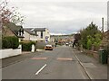
8
Dennistoun Crescent
The picture was taken not long before sunset. Not much further along this road, there is a path to Image
The street is surely named after the Dennistouns of Colgrain (Colgrain being the area in which the picture was taken); the family were long prominent here. Their original estate was the barony of Danielstoun or Danzielstoun(*) in Renfrewshire. The first of the family to be associated with the Colgrain area was Sir William Denzelstoun(*), as the surname was then spelled.
In a grant of 1377, Sir William is designated "Dominus de Colgrane et de Cambesescan" (modern Colgrain and Camis Eskan). The history of the family in the Colgrain area can be found on pages 437-458 of Joseph Irving's "History of Dumbartonshire" (2nd edition, 1860). The following information (aside from the end-note on spelling) is drawn from that work.
In many of the old local histories, "Dennistoun MS, Advocates' Library" is often cited as an authority. Since the Dennistoun Manuscripts are cited so frequently in local histories, and since they provided a very important source on which some of those histories were based, it is worth saying something about them here.
They were the result of the labours of James Dennistoun of Dennistoun (his father was the first of the family to be styled "Dennistoun of Dennistoun" – see p452 of Irving). James was born in 1803, and passed as advocate in 1824. As well as being occupied with his legal studies, he took the opportunity of researching and gathering a wealth of genealogical and topographical details and other information relating to Dumbartonshire and its historic families.
In 1836, he sold the family estate of Colgrain, and he afterwards purchased Dennistoun Mains, in Renfrewshire. Thereafter, his studies turned from the Dumbartonshire area to other matters, such as art and its related literature.
However, he had arranged that, after his death, his entire manuscript collection would pass into the hands of his friend, Mark Napier, Advocate, who would sort, arrange, catalogue and index the material. When this was done, the whole collection was properly bound to form eleven volumes; in 1856, these volumes were presented, according to the terms of Mr Dennistoun's bequest, to the Faculty of Advocates, in whose library this valuable collection would be kept.
As far as I know, they are now in the National Library of Scotland.
A footnote on page 457 of Irving's "History" specifies the titles of each of the eleven volumes. I generally dislike to quote long passages in full, but since it is otherwise difficult to find information about the 11 volumes online, I will gives their titles here, and brief descriptions, all quoted from Irving's "History". Regarding the title of the fifth volume, I should add that the adjective "Brittanodunensis" is derived from a Latinized version of the name "Dumbarton"; on "Bonyll" in the ninth title, see Image The volumes are as follows:
(1) A folio volume, entitled "Dumbartonshire Topography", being the first part of Mr Dennistoun's proposed history of that county;
(2) A folio volume, entitled "Dumbartonshire Families", being a genealogical account of the chief families in the county, and the second part of Mr Dennistoun's proposed work;
(3) A folio volume, entitled "Dumbartonshire Localities";
(4) A folio volume, entitled "Notes of Dumbartonshire Families";
(5) A quarto volume, entitled "Diploma Brittanodunensis", being a collection of ancient writings relating to the county of Dumbarton;
(6) A quarto volume, entitled "Buchanan Charters";
(7) A quarto volume, entitled "Wigton Writs", being notes from the charter chest at Cumbernauld House;
(8) A quarto volume, entitled "Notorial Protocols" — 1471 to 1515;
(9) A quarto volume, entitled "Corbett of Bonyll", containing tracts relating to John Corbet, minister of Bonhill;
(10) A quarto volume, entitled "Scot. Monasteries Abroad";
(11) A quarto volume, entitled "Notes from Foreign Libraries".
[(*) The spellings with z, Denzelstoun and Danzielstoun, represent Denȝelstoun and Danȝielstoun, with a letter yogh (ȝ). In this context, the letter yogh has the sound of 'y' (as in "yes"), but later spellings came to employ the letter z instead (likewise with the surnames Dalziel and Menzies, place-names like Culzean Castle and Cadzow, and so on). The family's original barony in Renfrewshire was therefore "Daniel's toun", a (ferm) toun being a farmstead with its various buildings and its surrounding area, rather than a town in the modern sense. On an unrelated point, I have consistently used "Dumbartonshire" above (not the modern "Dun-"), as the spelling in use at the time being discussed.]
Image: © Lairich Rig
Taken: 15 Oct 2012
0.08 miles
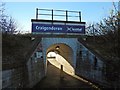
9
Subway entrance to Craigendoran station, 1994
View SW under the line to Helensburgh Upper, Arrochar and Fort William and then the branch to Helensburgh Central: ex-North British Glasgow Queen Street - Fort William 'West Highland' line, Helensburgh Central being the western terminus of the electrified North Clyde Lines of Strathclyde Transport, to The left being Dumbarton, Clydebank and Glasgow, then Shettleston, Coatbridge and Airdrie.
Image: © Ben Brooksbank
Taken: 22 Jun 1994
0.09 miles
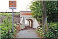
10
Entrance to Craigendoran Station
The subject is as in Image, but the picture was taken 22 years later. For the platform, see Image This path to the station begins on Image
Image: © Lairich Rig
Taken: 23 Nov 2016
0.09 miles