IMAGES TAKEN NEAR TO
Monaebrook Place, HELENSBURGH, G84 7JD
Introduction
This page details the photographs taken nearby to Monaebrook Place, G84 7JD by members of the Geograph project.
The Geograph project started in 2005 with the aim of publishing, organising and preserving representative images for every square kilometre of Great Britain, Ireland and the Isle of Man.

There are currently over 7.5m images from over14,400 individuals and you can help contribute to the project by visiting https://www.geograph.org.uk
Image Map
Images are licensed for reuse under creativecommons.org/licenses/by-sa/2.0
Notes
- Clicking on the map will re-center to the selected point.
- The higher the marker number, the further away the image location is from the centre of the postcode.
Image Listing (77 Images Found)
Images are licensed for reuse under creativecommons.org/licenses/by-sa/2.0
Image
Details
Distance
1
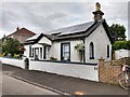
Old tollhouse
The 'main' road once went past this cottage in Craigendorran but now the A814 runs to the north. It was a tollhouse, known as Drumfork, for the section of toll road between Dumbarton and Helensburgh. This cut-off section of road is now named Monaebrook Place. Windows in the gable ends would enable the tollkeeper to keep an eye out for approaching traffic or herds of animals.
Image: © Hilary Jones
Taken: 10 Aug 2023
0.02 miles
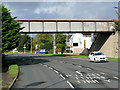
2
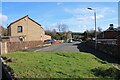
Monaebrook Place
Looking towards the railway bridge. This section of road was previously the main road into Helensburgh (Cardross Road). It joined East Clyde Street and Old Luss Road behind the camera position until a new dual carriageway was built just to the east Image
Image: © Richard Sutcliffe
Taken: 4 Mar 2024
0.03 miles
3
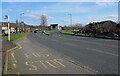
Cardross Road
The A814, Cardross Road is a dual carriageway for half a mile east from here.
Image: © Richard Sutcliffe
Taken: 4 Mar 2024
0.05 miles
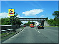
4
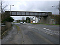
Railway bridge at Craigendoran
The bridge carries the West Highland line over the A814.
Image: © Thomas Nugent
Taken: 18 Mar 2011
0.05 miles
6
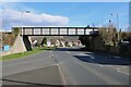
Railway bridge
The bridge carries the West Highland line over the A814, Cardross Road. The bridge was built when Cardross Road was realigned as a new dual carriageway to the east of its original route.
Image: © Richard Sutcliffe
Taken: 4 Mar 2024
0.06 miles
8
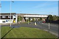
Railway bridge at Craigendoran
See Image for a view of this bridge from the other side, and for further details.
Image: © Lairich Rig
Taken: 3 May 2012
0.06 miles
9
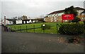
Colgrain Bowling Club
The bowling club was established in 1951 and has two greens. This one is overlooked by flats on Sunningdale Place.
Image: © Richard Sutcliffe
Taken: 11 Nov 2022
0.07 miles
10
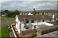
County Hotel, Helensburgh
Viewed from the train on the West Highland Line.
Image: © Mary and Angus Hogg
Taken: 4 Sep 2012
0.08 miles