IMAGES TAKEN NEAR TO
Nursery Street, HELENSBURGH, G84 7EA
Introduction
This page details the photographs taken nearby to Nursery Street, G84 7EA by members of the Geograph project.
The Geograph project started in 2005 with the aim of publishing, organising and preserving representative images for every square kilometre of Great Britain, Ireland and the Isle of Man.

There are currently over 7.5m images from over14,400 individuals and you can help contribute to the project by visiting https://www.geograph.org.uk
Image Map
Images are licensed for reuse under creativecommons.org/licenses/by-sa/2.0
Notes
- Clicking on the map will re-center to the selected point.
- The higher the marker number, the further away the image location is from the centre of the postcode.
Image Listing (67 Images Found)
Images are licensed for reuse under creativecommons.org/licenses/by-sa/2.0
Image
Details
Distance
1
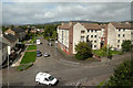
Helensburgh Houses
An early-September view, taken from the train on the West Highland Line.
Image: © Mary and Angus Hogg
Taken: 4 Sep 2012
0.03 miles
2
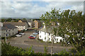
Helensburgh Houses
An early-September view, taken from the train on the West Highland Line.
Image: © Mary and Angus Hogg
Taken: 4 Sep 2012
0.03 miles
4
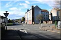
Crossroads
Old Luss Road runs from left to right. East King Street is straight ahead. The photograph is taken from Redgauntlet Road. On the other side, a lollipop lady is having a conversation while waiting for children from the nearby Colgrain Primary School to arrive.
Image: © Richard Sutcliffe
Taken: 4 Mar 2024
0.04 miles
5
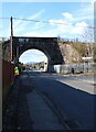
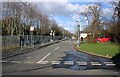
Bridge over Redgauntlet Road
The West Highland line crosses Redgauntlet Road. The figure on the left is a lollipop lady, waiting for the children (and parents) from the nearby Colgrain Primary School to arrive.
Image: © Richard Sutcliffe
Taken: 4 Mar 2024
0.05 miles
6
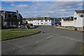
South King Street approaching Fire Station
Image: © John Firth
Taken: 14 Apr 2015
0.06 miles
7
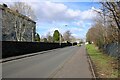
Old Luss Road
From the junction with Cardross Road and East Clyde Street. South King Street runs off to the left beside the properties in the centre, which are dated 1933.
Image: © Richard Sutcliffe
Taken: 4 Mar 2024
0.07 miles
9
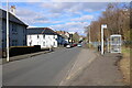
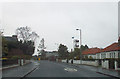
Redgauntlet Road
This section of Redgauntlet Road leads to Colgrain Primary School at the far end.
Image: © Richard Sutcliffe
Taken: 4 Mar 2024
0.07 miles
10
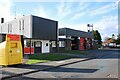
Helensburgh Community Fire Station
On South King Street.
Image: © Richard Sutcliffe
Taken: 4 Mar 2024
0.08 miles