IMAGES TAKEN NEAR TO
East Princes Street, HELENSBURGH, G84 7DF
Introduction
This page details the photographs taken nearby to East Princes Street, G84 7DF by members of the Geograph project.
The Geograph project started in 2005 with the aim of publishing, organising and preserving representative images for every square kilometre of Great Britain, Ireland and the Isle of Man.

There are currently over 7.5m images from over14,400 individuals and you can help contribute to the project by visiting https://www.geograph.org.uk
Image Map (Loading...)


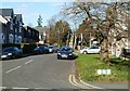
Getting Data...Please wait
Leaflet Map data © OpenStreetMap
Images are licensed for reuse under creativecommons.org/licenses/by-sa/2.0
Notes
- Clicking on the map will re-center to the selected point.
- The higher the marker number, the further away the image location is from the centre of the postcode.
Image Listing (216 Images Found)
Images are licensed for reuse under creativecommons.org/licenses/by-sa/2.0
Image
Details
Distance
1
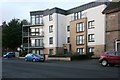
Flats on East Princes Street, Helensburgh
Image: © Richard Sutcliffe
Taken: 24 Dec 2019
0.02 miles
2
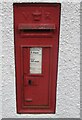
Victoria cypher postbox
East Princes Street, Helensburgh
Image: © Richard Webb
Taken: 26 Apr 2022
0.02 miles
3
Overhead electric gantry on railway near Helensburgh Central
Image: © Anthony O'Neil
Taken: 5 Jun 2010
0.02 miles
4
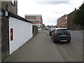
East Princes Street, Helensburgh
An old postbox Image
Image: © Richard Webb
Taken: 26 Apr 2022
0.03 miles
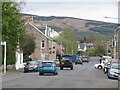
5
Lomond Street, Helensburgh
This street leads to a convenient footbridge across the railway line.
Image: © Mary and Angus Hogg
Taken: 1 Mar 2013
0.03 miles
6
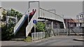
Footbridge across the railway near Helensburgh Central
Image: © Anthony O'Neil
Taken: 5 Jun 2010
0.03 miles
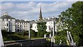
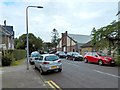
7
East Princes Street, Helensburgh
With a forested ridge off Killoeter in the background. Both East Princes Street and Princes Street East are found on street signs here.
Image: © Richard Webb
Taken: 26 Apr 2022
0.04 miles
8
Princess Street East
Looking east from the gas works.
Image: © Thomas Nugent
Taken: 10 Aug 2013
0.05 miles
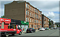
9
Lomond Street, Helensburgh
Not far ahead is one end of a footbridge over the railway line; Lomond Street continues on the far side of that bridge. The large building near the centre of the picture was employed as a drill hall during the First World War, and is currently a TA centre.
There was no building on that site when the first-edition OS map was surveyed in 1860. A long narrow building, captioned "drill hall", is marked on the second-edition map (revised c.1897). On the 1914 revision of the map, the building is much larger: it had been expanded to the south-west, and was almost square; this corresponds to its present-day appearance.
Another contributor's article lists the various buildings that were used as drill halls during the First World War: http://www.geograph.org.uk/article/WW1-Great-War-Centenary---Drill-Halls
Image: © Lairich Rig
Taken: 9 Jun 2014
0.05 miles
10
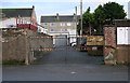
Gates to former Renault dealership, Charlotte Street
The wrought iron gates have 'A RANKINE' and 'RENAULT' in gold letters. These refer to Alex Rankine - a former Renault car dealership.
Image: © Richard Sutcliffe
Taken: 24 Dec 2019
0.05 miles