IMAGES TAKEN NEAR TO
Station Road, HELENSBURGH, G84 7BG
Introduction
This page details the photographs taken nearby to Station Road, G84 7BG by members of the Geograph project.
The Geograph project started in 2005 with the aim of publishing, organising and preserving representative images for every square kilometre of Great Britain, Ireland and the Isle of Man.

There are currently over 7.5m images from over14,400 individuals and you can help contribute to the project by visiting https://www.geograph.org.uk
Image Map
Images are licensed for reuse under creativecommons.org/licenses/by-sa/2.0
Notes
- Clicking on the map will re-center to the selected point.
- The higher the marker number, the further away the image location is from the centre of the postcode.
Image Listing (72 Images Found)
Images are licensed for reuse under creativecommons.org/licenses/by-sa/2.0
Image
Details
Distance
1
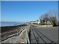
Middleton Drive, Craigendoran, Helensburgh
With a lovely view out to the Firth of Clyde.
Image: © Stephen Sweeney
Taken: 19 Feb 2013
0.02 miles
2
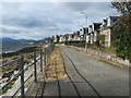
Middleton Drive
The photograph was taken from the point where the street meets Station Road.
Image: © Lairich Rig
Taken: 17 Sep 2010
0.04 miles
3
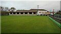
Colgrain Bowling Club
The bowling club was established in 1951 and has two greens.
Image: © Richard Sutcliffe
Taken: 11 Nov 2022
0.06 miles
4
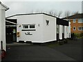
Colgrain Bowling Club
The clubhouse of Colgrain Bowling Club. Note the defibrillator on the wall.
Image: © Richard Sutcliffe
Taken: 11 Nov 2022
0.06 miles
5
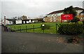
Colgrain Bowling Club
The bowling club was established in 1951 and has two greens. This one is overlooked by flats on Sunningdale Place.
Image: © Richard Sutcliffe
Taken: 11 Nov 2022
0.07 miles
6
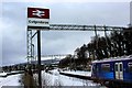
A Snowy Craigendoran Train Station
Here is a very snowy Craigendoran Train Station during the Beast from the East storms of 2018. Here we look at the Helensburgh end of the Station.
In the station is an abandoned Class 318 unit which had been left as it was stuck in a snow drift and couldn't continue any further.
Image: © Adam Forsyth
Taken: 3 Mar 2018
0.08 miles
7
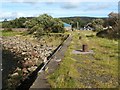
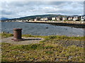
Old quayside at Craigendoran
See Image for further information about the quay and associated structures.
The quayside retains some of its original bollards: Image However, few other features have survived; the short section of railway line that served the quay is long gone.
The footbridge of the present-day Craigendoran station can be seen in the background.
Image: © Lairich Rig
Taken: 17 Sep 2010
0.09 miles
8
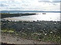
Old quay and piers at Craigendoran
The side of the quay can be seen on the left, with grass on top. For other views, and for more information, see Image and Image
To the right of the quay are the remains of two piers, which are described in Image; in an earlier photograph by another contributor, they are seen from another viewpoint: Image
The present photograph was taken from the junction of Middleton Drive and Station Road; more specifically, it was taken from the railings that appear in the foreground of Image
Image: © Lairich Rig
Taken: 17 Sep 2010
0.09 miles
9
Old quayside (detail)
See Image for context, and Image for the main discussion (with links to further information and images).
The present photo shows part of the cobbled surface of the quay, and one of the original bollards.
In the background, the row of houses on the right is Image
Image: © Lairich Rig
Taken: 17 Sep 2010
0.10 miles
10
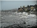
Scavenging gulls
A flock of black-headed gulls scavenging on any food items disturbed by the strong, breaking waves at Craigendoran. The birds would fly up as the next breaker moved in and then dive down again to see what they could find. Helensburgh is in the distance.
Image: © Richard Sutcliffe
Taken: 11 Nov 2022
0.10 miles