IMAGES TAKEN NEAR TO
Argyll Road, HELENSBURGH, G84 0RP
Introduction
This page details the photographs taken nearby to Argyll Road, G84 0RP by members of the Geograph project.
The Geograph project started in 2005 with the aim of publishing, organising and preserving representative images for every square kilometre of Great Britain, Ireland and the Isle of Man.

There are currently over 7.5m images from over14,400 individuals and you can help contribute to the project by visiting https://www.geograph.org.uk
Image Map
Images are licensed for reuse under creativecommons.org/licenses/by-sa/2.0
Notes
- Clicking on the map will re-center to the selected point.
- The higher the marker number, the further away the image location is from the centre of the postcode.
Image Listing (15 Images Found)
Images are licensed for reuse under creativecommons.org/licenses/by-sa/2.0
Image
Details
Distance
1
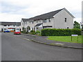
Broom Road
A view looking east towards Broom Road
Image: © Phil Williams
Taken: 28 May 2006
0.01 miles
2
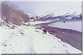
Rosneath Beach
Looking north along the beach at Rosneath towards Rhu Narrows on a wintery January afternoon. Ferryboat Cottage can be seen in the distance at centre, and the remains of the old pier can be seen in the water to the right.
Image: © Phil Williams
Taken: Unknown
0.06 miles
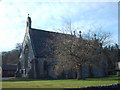
5
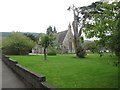
The church at Rosneath
At the heart of the seaside community.
Image: © James Denham
Taken: 18 Sep 2014
0.10 miles
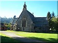
7
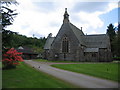
St. Modans, Rosneath
A view looking west from Tom-a-Mhoid towards the church of St. Modan. A plaque at the entrance to the churchyard states " There has been a Christian church in Rosneath since the time of St. Modan in the 7th century. Near the present Church are the ruins of an earlier sanctuary surrounded by an Historic Churchyard."
Image: © Phil Williams
Taken: 28 May 2006
0.13 miles
8
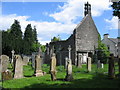
Sanctuary ruins
A view looking southeast over the old churchyard to the ruins of the sanctuary building at Rosneath.
Image: © Phil Williams
Taken: 28 May 2006
0.13 miles
9
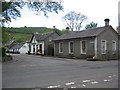
The Clachan
A view looking west across the B833 towards the Clachan. The entrance to St. Modans church is to the left of the image.
Image: © Phil Williams
Taken: 28 May 2006
0.13 miles
10
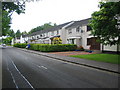
Tom-a-Mhoid
A view looking southeast along the B833, Tom-a-Mhoid. These houses were built by the Scottish Special Housing Association (SSHA), but most are now in private ownership.
Image: © Phil Williams
Taken: 28 May 2006
0.13 miles