IMAGES TAKEN NEAR TO
Barbour Road, HELENSBURGH, G84 0PG
Introduction
This page details the photographs taken nearby to Barbour Road, G84 0PG by members of the Geograph project.
The Geograph project started in 2005 with the aim of publishing, organising and preserving representative images for every square kilometre of Great Britain, Ireland and the Isle of Man.

There are currently over 7.5m images from over14,400 individuals and you can help contribute to the project by visiting https://www.geograph.org.uk
Image Map
Images are licensed for reuse under creativecommons.org/licenses/by-sa/2.0
Notes
- Clicking on the map will re-center to the selected point.
- The higher the marker number, the further away the image location is from the centre of the postcode.
Image Listing (3 Images Found)
Images are licensed for reuse under creativecommons.org/licenses/by-sa/2.0
Image
Details
Distance
1
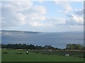
Sheep grazings off the Barbour Road
A view looking to the south-southwest over sheep grazings off the Barbour Road on the Rosneath Peninsula. Knockderry castle can be seen in the trees in the upper foreground with Cloch Point and the chimney at Inverkip power station visible across the Firth of Clyde.
Image: © Phil Williams
Taken: 28 May 2006
0.24 miles
2
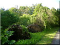
Uprooted larches
This pair of larches were uprooted during the storm of 23 May 2011.
Image: © Mark Nightingale
Taken: 30 May 2011
0.25 miles
3
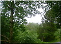
Trees battered by storm
Trees struggling to remain upright during the storm of 23 May 2011. The larches to the right of the photograph were later uprooted Image
Image: © Mark Nightingale
Taken: 23 May 2011
0.25 miles