IMAGES TAKEN NEAR TO
Cove, HELENSBURGH, G84 0PE
Introduction
This page details the photographs taken nearby to G84 0PE by members of the Geograph project.
The Geograph project started in 2005 with the aim of publishing, organising and preserving representative images for every square kilometre of Great Britain, Ireland and the Isle of Man.

There are currently over 7.5m images from over14,400 individuals and you can help contribute to the project by visiting https://www.geograph.org.uk
Image Map
Images are licensed for reuse under creativecommons.org/licenses/by-sa/2.0
Notes
- Clicking on the map will re-center to the selected point.
- The higher the marker number, the further away the image location is from the centre of the postcode.
Image Listing (35 Images Found)
Images are licensed for reuse under creativecommons.org/licenses/by-sa/2.0
Image
Details
Distance
1
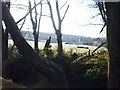
Peaton Through The Trees
View towards Peaton House
Image: © Lynn M Reid
Taken: 8 Apr 2008
0.02 miles
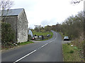
2
Road to Gareloch
Time to get off the bike and push
Image: © william craig
Taken: 13 Oct 2005
0.03 miles
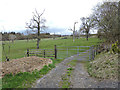
4
Peaton Farm
Looking down on the farm from Peaton Road.
Image: © Thomas Nugent
Taken: 27 Apr 2015
0.03 miles
6
Peaton Road
Peaton Farm is on the right.
Image: © Thomas Nugent
Taken: 27 Apr 2015
0.03 miles
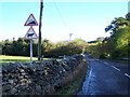
7
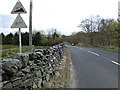
Peaton Road
The start of the 17% climb to the top of Peaton Hill.
See the same view before the paintwork on the signs faded Image
Image: © Thomas Nugent
Taken: 27 Apr 2015
0.04 miles
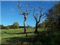
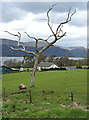
9
Farmland off Peaton Road
Near Peaton Farm.
Image: © Thomas Nugent
Taken: 27 Apr 2015
0.07 miles
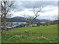
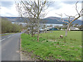
10
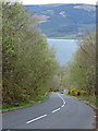
Peaton Road
Looking down the hill towards Loch Long.
Image: © Thomas Nugent
Taken: 27 Apr 2015
0.08 miles